
Snow Reports from Warren County, NY

Gore Mountain phone call 10:30 am: Emily is out West, but her backup answered the phone. She indicated that 6 inches of snow fell before precip stopped overnight. I pushed on NCP. She’d spoken to the groomers and they made no mention of anything but snow overnight. Apparently it’s wet at the bottom, because that was how it fell. She said she’d call it packed powder.

I told her she should post it up, people REALLY want to know what is up. She said she’d talk to patrol first, and then update the site.


From the Garnet Hill Website, 9:30 am: “Friday, Feb 26th – 38″ of fresh snow. Trails are open as we are clearing down branches. We hope to commence grooming this afternoon after branches are cleared and the snow has time to dry.”


Email, Emily, 9am: Spoke to Patrol. No mention of NCP.


Email, North River, 1200 feet, 8:30 am: Snowed til midnight then NCP all night after that.


Email, Igerna Hermit, 1100 feet, 7:00 am: “Reporting from my station – 1.06″ ncp yesterday and .61″ ncp all last night ending this morning.”

Jamesdeluxe Interviews Belleayre’s Joe Kelly

You may or may not know that Jamesdeluxe is actually a writer by trade. He’s also a Belleayre regular and is very interested in the future of the hill.

Linked below is his interview with avid Belleayre supporter Joe Kelly, about the future of the mountain in the Catskills. Even if you’ve never skied Bell, it’s a compelling look at an passionate group of Belleayre advocates that has worked hard to keep the mountain alive over the decades. It should be interesting for NY skiers to note the differences between Belleayre and the other two ski state-run mountains.


Continue reading

Mega-Storm Potential

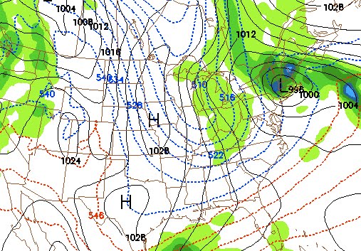
Next week’s system will be complicated. 2 lows, with a lot of reforming. A 500mb low. Very difficult to forecast. Right now ALL the models cut-off the low in New England. This could be a long duration event.

Jason’s a real weatherguy. He’s got to go by the rules. Multiple model runs, different models, credibility. Blah, blah, blah. I’m just a stokemeister. I poked my way into the GFS. If you follow it out, the model shows multiple events on the horizon. The image above depicts a mega storm late next week. BRING IT.

Jason will be out with some legitimate weather analysis Sunday evening.