Gore Mountain, NY: 1/18 and 1/19/08

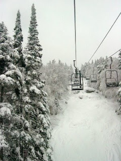
I’d been planning on skiing this weekend for over a month, pending conditions. I had the proverbial “4-hour window” on Friday afternoon to meet with the local phone company, so the plan was to ski the morning and then head back to the cabin.

Earlier in the week, I’d been hit with the most heinous “flu” or something and was completely knocked out. I missed 2 days of work – only my 4th and 5th sick days in 22 years with my current company. So I went back to work Thursday, booked out early for the drive to the mountains. Arrived at about 8pm, started the stove and got to bed around 11 pm exhausted, not sure how I could possibly ski.

Continue reading

Gore Mtn, NY: 12/28/07 – 1/5/08

Dark SideI’m having a hard time with this post. When you ski 9 days straight, it’s tough to remember exactly what happened. This much I reasonably sure of:

Thurs 12/27 pm: Arrived to find ankle high snow on the path, fallen since our last visit. We heated our building, made some dinner, watched some Elmo, hit the sack. It snowed 4″ that night.

Friday 12/28: There was talk of a mix, but when I walked through it in the AM, it was fluffy. The whole mountain skied very nicely. I think 2 or 3 glades were open, The Cave, Pinebrook, I forget. Surfaces were soft almost everywhere. 50/50 maybe locals and flatlanders. That night the call was for a mix after midnight.

Continue reading

Powderfreak’s Forecast for New Years

From Scott Braaten aka Powderfreak: The snow worked out a little better than planned at the lower elevations today…I’m surprised there were so many 3″ or greater amounts in generally valley locations. Most resorts should be reporting a general 3-7″ tomorrow morning. That’s pretty good news.

1) Friday night and Saturday’s event looks like a moderate snowfall with amounts of 4-7″ in the Green Mtns from SB/MRG northward and eastward (1-4″ Adirondacks and BTV). An isolated higher amount is still possible just north of the sleet mixing line, which I still think will be in the vicinity of Glens Falls-Rutland-Lebanon. I think I posted earlier this week that MRG/SB region looks like the bullseye and I’m sticking with that…but man is this a tough call with sleet/freezing rain not far away. Just an FYI, the NWS has included sleet all the way to northern Vermont. This very well may be correct but I just don’t see the warm air penetrating that far north.

Continue reading