Snowfall Forecast Map for 2011-2012

Snowfall Forecast Map for 2011 - 2012.

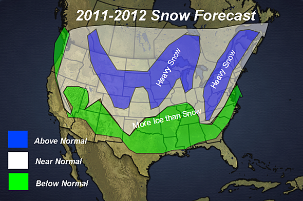
With the departure of Joe Bastardi, it looks like Henry Margusity may be the new go-to-guy for long-term winter weather forecasting at Accuweather. He just posted the snowfall forecast map above with his preliminary call for the winter of 2011-2012. Obviously it’s a long way off, but we like the way it looks. An excerpt from the full forecast:

“The basis of the forecast is on the prediction that a weak La Nina will be forming this fall and continuing through the winter. While the pattern will be similar to last year, there will be changes in the pattern that will lead to the heavy snow areas shown on the map.

Continue reading

Jason’s Weather: 1/31/11

The latest GFS 0z and 6z are pointing towards a major snow event for the Catskills, Adirondacks and all of ski country. Both runs are a little weaker and further south than previous runs with the 500mb closed low.

This is a good thing because this storm track should shut off warming aloft. Normally a storm track like this one could deliver a mixed bag of precipitation types for New York and the Northeast. In this case, the position of the High in eastern Canada is crucial in the set up — it will hold all that cold air in place. Bottom line: as of 7:30 a.m. Monday, we’re calling for 12-24 for all of the major ski areas.