
Dec 8: After having a great run of cold weather and significant snow for some areas, we have to deal with a bump in the road. The storm that is currently giving the Cascades huge amounts of snow will move into the Lower Ohio Valley and strengthen, then it will move up the Appalachians to Central NY and on into Canada.
This scenario would put much of the Adirondacks and New England on the warm side. After the low pulls away, Lake Effect and upslope snows will follow. For some areas, the snow will be heavy. In the storm’s wake, we’ll experience the coldest air of the season.
UPDATE 12/9:
After the last model run, it seems likely that the low will go just west of or through the Adirondacks. Saturday should be mostly sunny and seasonable. Sunday will feature a potpourri of weather. At the start of the event, there should be some light snow that will quickly change to sleet, then r**n. On Monday, the NCP will change back to snow, and we could be in line for another major upslope and lake effect event. At this time, it doesn’t look like a huge amount of unfrozen precip is in the picture.
More tomorrow on timing, and hopefully, another flipflop.
Hmmmm. Outlook for Monday – Wednesday?
Monday – wednesday should be snowy, windy and brutally cold.
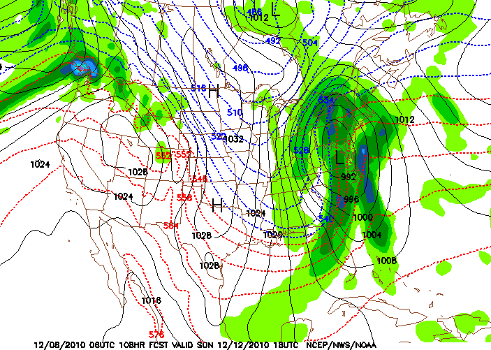
Just looked at the 12gfs..the run definitely has a colder look to it, the low is a little further south and east..this could be very good news for the ADKs..Tomorrow we should have a clearer picture..
I’m liking the GFS which was the MRF I posted. Just reading the NWS Albany discussion and they are starting to bend. It is still a crap shoot this far out but the more positive vibes we can emit…
Think Snow!
I usually don’t like to use the 06z or 18z runs to make a forecast. But the 18z GFS was so different than the 12z I had to mention it. The 18z now shows a low going well off the coast , effectively negating any possibility of rain…Now lets see if it’s a trend or a bad run and the 0z reverts back to a low in Central NY.
Classic NWS uncertainty the European and GFS models are polar opposites so the NWS sums it up in this morning’s discussion:
“IN SHORT…WE COULD END UP GETTING BURIED…FLOODED…OR A MESS OF SLOP AND SLEET…WITH THE LIKELY OUTCOME BEING MOSTLY SNOW NORTH AND WEST…MOSTLY RAIN SOUTH AND EAST…AND A MESSY MIX IN BETWEEN.”
Suds, that is the best..so classic.. but in their defense the models are flip flopping more than a politician..
A friend and former TV Meteorologist Norm used to go out on a limb using his local knowledge. He always said Bob was going to fire him but he was right more than Bob. He was the best area weatherman we ever had…RIP (there was an epic snowstorm the day of his funeral). I am planning on a ski day Monday.
Are you talking about Norm Macdonald from Boston?
Sabastien from albany just didn’t know how to spell his last name.
My wife and I were bummed when Norm passed. He seemed like a good guy. It’s going to be a Bow Wow bone chiller.
🙂
Guys, I’m totally disgusted with the inconsistency of the GFS..Yesterday 18z then 0z had the low further east and colder..Today 12z is back to driving the low right up through Central NY. Thus giving everyone a mixed bag to rain..Then followed by a cold windy stretch of weather..I’m sure I will have to update this many more times..
“A STRENGTHENING LOW PRESSURE SYSTEM WILL APPROACH FROM PLAINS AND IMPACT THE REGION SUNDAY INTO MONDAY.”
Above is the Albany NWS discussion and below is Burlington…at least we can agree there will be a big storm…I am still planning to ski Gore on Monday…Maybe Whiteface…my confidence level is below average.
“WITH MODELS OFFERING DIFFERING SOLUTIONS AND LIMITED RUN TO RUN CONSISTENCY…THE RESULT IS BELOW AVERAGE FORECASTER CONFIDENCE. ALL MODELS DO SUPPORT A MAJOR WEATHER EVENT…WITH DEEP LAYER MOISTURE ADVECTION AHEAD OF DEVELOPING FULL LATITUDE NEGATIVELY TILTED TROF.”
Go with the Euro Jason, had this storm nailed for days.
Nor 27 you are 100% right..all the other models were all over the place.. The Ukmet was a real disaster. It had the low in the box the whole time..
Also i had trouble accessing the ECWMF ..The site was up and down. I hate using UNISIS..
0z and 12z Euro indicating some potential late next week, gfs shows nothing but suppression. Something to track this week.
Current Euro is pretty flat too.