
This week’s storm presents a rare case: a disturbance tracking to our west is going to produce a measurable snow storm. This is due in part to some redevelopment off the coast, but the primary driver of this event is a vigorous upper-level low.
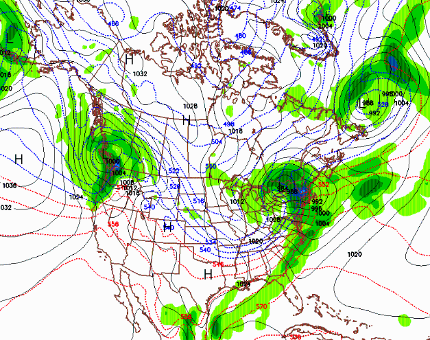
The map above is the surface forecast for 10pm tonight. Note the tightly wrapped low over Lake Ontario. As far as accumulations, the last model run has backed off the qpf and I’m calling for 2-4 inches of snow in the Catskills, 4-10 in the Adirondacks, and 6-12 along the top half of the Green Mountain spine in VT. Models are showing from .5-1 inches of liquid equivalent.
There may be some more on the backside snow in favored upslope areas. As is often the case with storms on the east coast, wind will be a issue late Friday and Saturday and may effect lift operations.
This is going to make for an interesting drive this evening…..
Mixing? Looks like the Cats are getting RAIN right now (5pm Fri 2/24). Or – as the title implies – is the 2-4 Cats forecast for what happens tomorrow?
@Anon – my bad on the title date – it should have read today’s date (2/24). Not Jason’s mistake.
I’m being very generous with those numbers…wouldn’t be surprised to see the Cats goose egg..
NOAA WF 3800 foot forecast reduced to 1-3 tonight and 1-3 tommorrow. So this appears to be a dud – big question is how windy will it be Saturday?
This storm is the whole season in a busted nutshell.
Hence my forecast…
So was this an “irrationally exuberant” forecast or a realistic post? Looked like a gully washer in Cats all day.
The storm is a bust!! 24hrs ago the models had 1.5″ of liquid, that has been cut by 75%. looks like lower end of forecast will verify..
It must have moved north. I just blew 8″ out of my driveway and it is still snowing. Plus, check out Warp Daddy’s Titus report.
I can’t speak for other Catskill areas, but I spoke to Laszlo (Plattekill) last night. They’d had 3″ at the base in the morning on Friday (more up top) and precip turned back to snow last evening around 10pm. Right now radar seems to show snow as well. Will be interesting to see final snow totals for all areas of NY. I wouldn’t be surprised to the Adk areas in the middle or high end of Jason’s range.
Maybe higher up WF will be better but at 1200 feet 4-5 miles from WF we got a whopping 2″ – total bust.
Cats = 3″ by 9am, back to snow 10pm + the part you’re leaving out… whole lotta rain in between.
Plattekill is reporting 2 inches new this morning.
Looks like WF is reporting 6″ right now. But, looks like almost everything is on wind hold.
🙁
Wind Sucks.
“There may be some more on the backside snow in favored upslope areas. As is often the case with storms on the east coast, wind will be a issue late Friday and Saturday and may effect lift operations.”
Yup, this is pure genius, in hindsight. Still snowing in Killington Sat. night.
@anon – Jason’s forecast was made at 11am on Friday and revised downward at 1pm after he saw the next model run. There was no attempt to deceive – forecasting precip type in the transition isn’t easy. Ultimately the forecast was classic Jason – well researched, thought through and on the conservative side. If it makes you feel any better Plattekill got significant snowfall today, exceeding Jason’s estimate. What was your call?
Nuked all day at Stowe. We just measured another 9 on the car since 5pm.