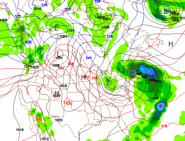
The model runs are finally starting to converge. Wednesday’s 18z GFS and NAM are calling for a developing coastal low that stalls over the Gulf of Maine. This will bring moderate to heavy rains to the mountains.
What makes this system interesting is that there will be just enough cold air aloft and strong vertical velocity for wet snow to fall in the Adirondacks above 3,000 feet. Amounts are hard to pin down due to the fact that there really isn’t much cold air at the surface.
The first snowfall in the northeast is always fun to predict and watch.


Jason’s first weather post… if only THAT could be scheduled and put on the Ski Season Calendar. Accumulations on the summits?
It would be great to see some snow at the higher elevations out of this one: last year, Sunday River opened on October 15th, and while they tested their snow guns last weekend, they were unable to lay anything down on the ground. Also, most Adirondack and VT areas recorded a first snowfall around Oct 3rd last year. Of course, last November was a warm one, with Thanksgiving opening dates postponed at Gore and everywhere else, after the first snowmaking all melted away.
I would rather have a warm October and a cold November, when everyone can lay down snow for an early opening. October snows are “stokes” but not much more. It’s been quite warm down in the mid-Atlantic, Snowshoe Mountain region where I live these days (though Snowshoe last week received a measurable snowfall before any ski area up north.) Think Cold and Snow!
Check out The Weather Channel Friday afternoon: they have Jim Cantore (yes, he can get annoying out in hurricanes) reporting LIVE from the base of Stowe, holding a snowball he just made. Predicting 4 – 6 inches in higher elevations in VT. Yes I know this is NY Ski Blog, but that’s the best this old kid can do.
Kid … NYSkiBlog is a NY Skiers site, not just a NY Ski Area site. Vermont is important to NY skiers. An October eastern snow is always noteworthy.