I was looking through last summer’s long range forecasts. What I found looks pretty good in retrospect. Caveat: I haven’t followed the weather out west. We’re really looking at the Northeast.
Bastardi’s Call
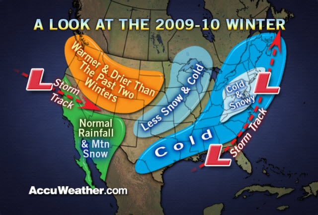
The biggest, baddest of all the long term calls comes each summer from Accuweather’s Joe Bastardi. Accuweather is known for making bold calls and hyping them bigtime. They’ve gone down in flames recently, including Bastardi’s call for 08/09. This year his call, made in mid-July, was SPOT ON for the northeast.
National Weather Service Forecast
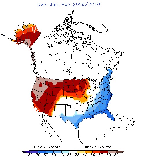
Another call that looked pretty accurate in hindsight was NWS/NOAA’s 3 month temp outlook, published in early November:
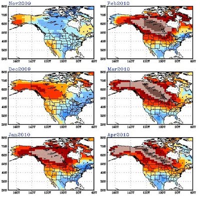
And finally this analysis, on the effect of El Nino, I think described the winter extremely well. Warmer than average most of the winter across most of Canada and the upper midwest. Colder than average along the East coast for Dec – Feb, with the warmth finally reaching the coast in March and April:
When we first saw this image on November 2, we said:
“… at this time of year – it’s all about temps. If we get our share of arctic air, snowmaking can begin, and precip will fall into place. If we could get those Jan-Feb temps to verify, I’d take my chances with March and April.”
And even though Accuweather basically laid it out … I had NO IDEA what this would mean if it verified. Blizzards in NJ and a snow drought in the mountains.
While the season wasn’t ideal by any means, at the beginning of the season cold air is the ultimate commodity. And we’d bet, in the same situation, we’d make that deal with the devil again.


I mentioned this in Jason’s “The Big One” thread… Accuweather nailed the late February Catskills storm with a big, macho forecast and maps that actually panned out.
Maybe Jason can help with this, but how the hell do you predict (in July no less) a blocking system that’ll bring big snow like that from the Catskills to VA? The geographic precision of that call is uncanny.
I was thinking about those long range forecasts recently. A lot of the long range forecasts really nailed the MASH snowy winter. BUT northern New England really was not that cold.
Without looking at the actual average temperatures, I have to believe that northern New England was slightly above average temperatures this past winter at least, if not significantly above normal. Perhaps that was due to what I understand was an El Nino that was stronger than expected?
The cold track through NY and the cold and snowy bullseye were both right on, though.
It is hard to imagine where the data comes from and how it gets analyzed.
Steve – not sure specifically about NoVT. But I had the same impression in the Adks. Didn’t seem that cold. There certainly was no extreme cold all winter.
But … with the exception of the big ugly .. the ncp event in late Jan … we really did not go above freezing. I think that event only featured about 36 hours above freezing. In the Adks, the consistent “cool/cold” with very little warmup, led to a below average Dec-Feb.
What they basically do is take current atmospheric and oceanographic data. Then compare it to past data and what that data yielded in terms of actual weather… they also have long range weather models too..then of course there’s the ouija board and pin the tail on the weather map…