
I often spent my summer vacations visiting the Liverpool Public Library, where numerous magazines were archived. Growing up in Central New York during the 1960s, I was introduced to skiing on a neighborhood hill and became interested in finding out about the places that offered this sport to the public.
For Christmas 1966, my parents gave me an Eastern Ski Atlas, which detailed the many places to ski in the northeast, including pictures of trail maps. I can vividly remember being taken to the various names and locations from the maps and even writing the ski areas to obtain their brochures. This led to collecting and comparing road maps sold by several different gas stations, which also indicated where ski areas were. Some maps had the same locations noted while others did not, so I eventually created one map showing all of these locations collectively.
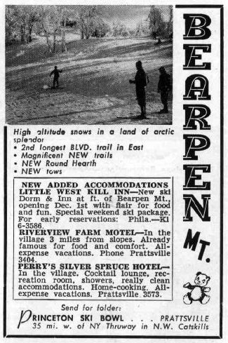
At the library, the older ski magazines mentioned a place in the Catskills called “Princeton Ski Bowl.” I noticed that the gas station maps I’d collected never had it listed. I began noticing that this happened often with other locations, but being new to all of this, I couldn’t figure out why. Many of these locations had “wintry” names and/or included “mountain” as part of what they were called. Princeton Ski Bowl, located in the Catskills, struck me as a funny name for a place to ski. Also, the little bear, seen in the ski magazine advertisements seemed unrelated.
In 1969, my family moved to the Albany area, which began a three-decade quest to experience for myself what northeastern skiing was all about. After numerous trips in the 1990s across the northeast, the western states and Canada, I returned to the curiosity of my youth and began investigating Catskill ski history. People I spoke with often mentioned Bearpen in terms of its overall importance. They related to me that because of when and where this area operated, many locations that we ski today came to be. What I had forgotten was that Princeton Ski Bowl was, in fact, Bearpen Mountain. I kept hearing about it, but did not make the connection until later.
Everyone talked about Bearpen in almost reverential tones, like it was “the one that got away.” I found it interesting that no one really mentioned why it was no longer there. Later, the truth attached to this secret slowly unfolded. Sensing my passion, people all said, “You need to learn about Bearpen! You need to go see Bearpen!” In those days, when artificial snowmaking did not exist, many older people told stories of skiing at Bearpen in the middle of May. For me, in the Catskills, this seemed ridiculous, but I kept an open mind. Still, I kept thinking, “If it’s so great, why haven’t I heard of it before?”
First Visits to Bearpen
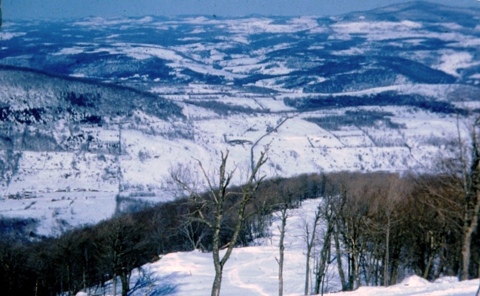
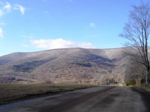
As information slowly trickled in while checking out other places to ski in the Catskills, a trip to Bearpen fell into place. I drove through the small town of Prattsville, over a steel bridge, and took a left onto Greene County Route 2. This wandering uphill road finally leveled off to a view of a massive ridge with two huge peaks on either side: Bearpen in all its magnificence. Moving on, I traveled another half mile to the next ridge and witnessed this magnificence yet again, but this time with depth! Remaining on Route 2, I drove downhill into Little Westkill Valley, where I parked and began my trek into the woods. Since this land was posted with New York State land signs, I knew I was not trespassing.
As I hiked uphill, I came upon stone walls running across the downhill contour and newer tree growth mixed with patches of grass. I determined these to be originally pastures. Farmers had used the stone to section off their property boundaries and Mother Nature had taken over due to it no longer being used. As it related to the existence of a ski operation, what I saw did not make sense. From the valley floor, ski trails were clearly visible coming down from above. However, because the stone walls had not been disturbed (at least in the area I had explored), the trails could not have reached down to this particular base location. This told me that the ski mountain could not have been operated from the valley and had to be an upside-down creation similar to Intermont, a Central New York area I had skied in my youth.
I returned to my car and continued through the valley about a mile, where the road intersected Greene County Route 3. I followed this road to the point where it became dirt. On my left stood Vly Mountain with its own unique character, creating an incredible feeling of depth. Steeper than Bearpen, I envisioned continuous expert terrain that was twice as long as “Outer Limits” at Killington. This mountain is the icing on Bearpen’s cake.
A few days later, I made contact with Bob Hull, the Roxbury town assessor. Well-versed in the history of the area, this fantastic gentleman answered many of my questions. Over the course of three phone calls, Mr. Hull did several things. Initially, he opened the door to speak with Bruce German, one of two men who created the Roxbury Ski Center, aka “No Name.” This aspect is a topic onto itself, but ties to Bearpen in an interesting way.
In preparation for the first season the Princeton Ski Bowl operated, the town of Roxbury granted a permit on the western side of the mountain for the existing but well eroded Vega Road to be regraded. This work would allow connection to an additional parking lot in that valley for those who came to ski. Initially, Bruce German, along with his soon-to-become partner, Romeo Signetti, would become the employees who ran that lot.
The following year, the permit needed to access that area would be denied. Inspired by what the operation had become, German and Signetti acquired the land that the road ran through the middle of and began construction of the Roxbury Ski Center. Mr. Hull also told me about the way it snowed in these parts. He mentioned that the ski area closed once because it snowed too much, which brought me back to what I had heard earlier about being able to ski the mountain in May.
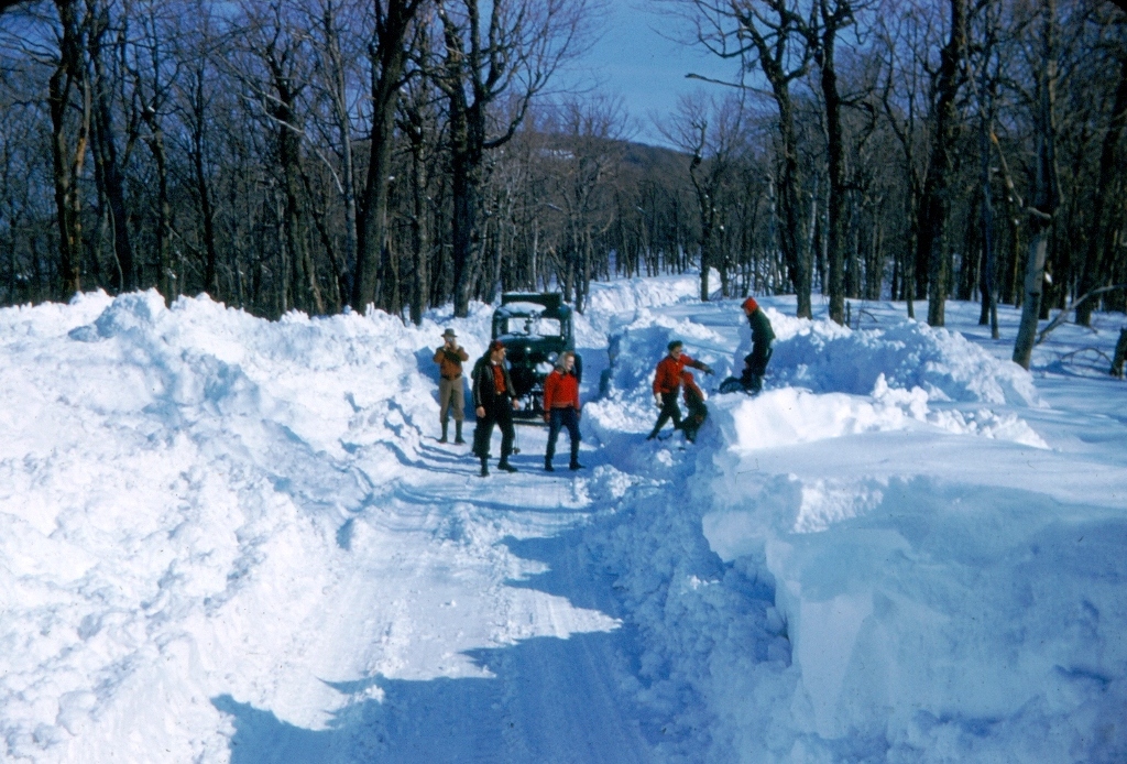
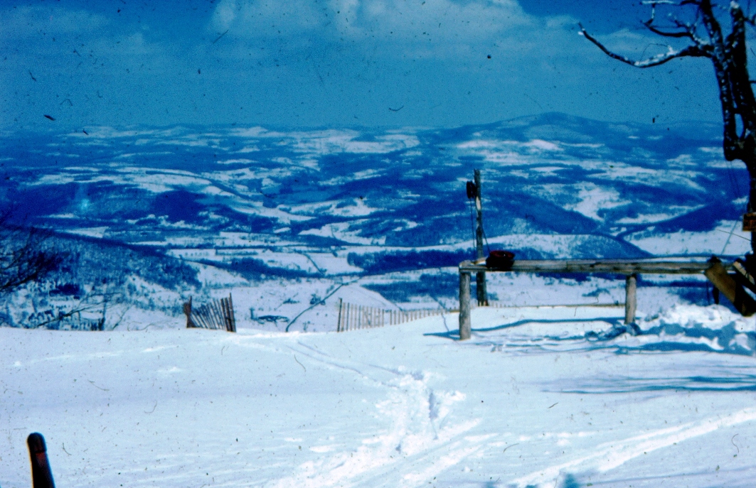
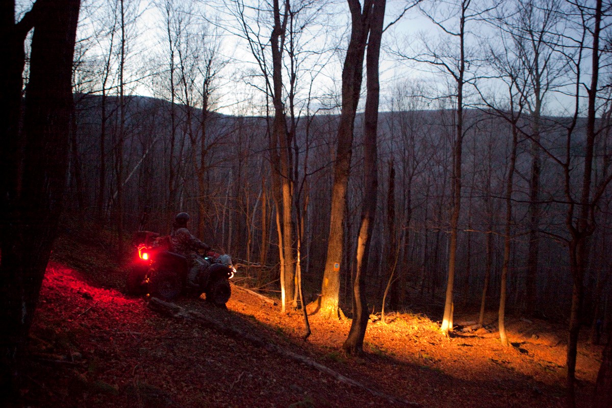
Through our last phone call, Bob made arrangements for me to meet with his son Dennis, who would take me up on the mountain via ATV two weeks later. We rode from his home to a dirt road labeled, at that time, “Ski Run Road.” This road was explained to me as the path traveled by old army trucks — vehicles that brought skiers up to and across the summit ridge ending at a small parking lot, which was the unloading area (elevation 3,500 feet).
Bearpen’s Stats
After traveling a small distance, we came across a rectangular pond and some cinder blocks: remnants of the summit lodge. Continuing past this point, old ski trails, yet to be fully taken over by nature, became easily seen. I was also shown a couple of old trucks that had been used to power rope tows. At the absolute summit, a powerful engine was still in place, which he described as being the drive for the main rope tow. It was at this point that I finally understood why Bearpen was still a big topic around the area. Its northeast exposure and continuous fall-line of 1,900 vertical feet to the valley would be considered excellent criteria for any ski area. Through the use of topographical maps, I would later discover that Bearpen had an overall vertical drop of 2,120 feet: unheard of for lift-served skiing in the Catskills.
Moreover, Bearpen sits right in the middle of everything in the Catskills with gorgeous views in every direction. Depending on where one is on the mountain, Plattekill can be seen to the west, the backside of Windham to the east, Hunter West to the southeast, and Belleayre/Highmount to the south. On this particular day, the air was crystal clear, offering a beautiful view of the distant Adirondack foothills near Northville, the Berkshires, and many of the Catskills high peaks.
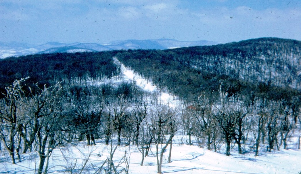
There were also some intangibles at work; things only a skier could appreciate. Most important was the feeling of depth, with spurs similar to the fingers of a hand that was unlike anything I had experienced at any of the large northeastern ski areas. A certain feeling came from the manner in which the trails were cut — using what the mountain offered rather than creating the skiable terrain anew. All this terrain is at the center of a 4.5-mile ridge at 3,500 feet, along with another 100 vertical feet at the actual summit. The north end of the mountain develops into a horseshoe shape, which creates an ideal protected location for a valley base village.
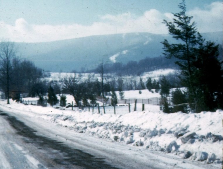
Bearpen apparently has no issues receiving its annual average snowfall of 200 inches. Similar to Plattekill, it is in a naturally advantageous position to grab snow, including lake-effect precipitation. But there’s more. On the west escarpment, there are two huge terrain “scoops” that drive wind (and with it, snow) up toward the top of the mountain. Plattekill experiences a similar, but lesser phenomenon across its varied exposure.
The ski area at Bearpen was positioned at the center of where these two scoops meet. This same west wind carries the snow over and onto its northeast-facing trails, helping to build the snow base. During a visit one winter, I stood at 3,000 feet and saw this incredible phenomenon actually happen — watching snow fall onto the mountain from above and simultaneously rise from below.
Anyone who has been to such great northeastern mountains as Mad River, Mount Ellen, Stowe, and Sugarloaf can understand what makes those ski areas special. Bearpen, without a doubt, belongs in that group. What makes it even more attractive is its location: only 2.5 hours from a huge population to the south.
Meeting Bearpen’s Founder
After my original ATV tour, Dennis Hull got me in touch with Prattsville native Tom O’Hara, who transported gas to the summit of Bearpen to run the tows when the ski area was in operation. Tom was also an ATV rider and took me to the summit, where he gave a detailed description of the mountain back then. Thanks to Tom, I was able to establish contact with the man who built Princeton Ski Bowl, Dr. Benjamin Lane, an eye doctor from New Jersey. Through his local contacts, Mr. O’Hara was able to provide me with his address.
At this point, the year 2000, I wrote a letter to Dr. Lane explaining my interest and asking for his help. This letter met with no response. After a second effort, I was able to get through to Dr. Lane at his office. He explained that my letter was sitting on his desk, and that he had intended to contact me, but his busy optometry practice kept getting in the way. He explained that no one had ever tried to contact him regarding the Ski Bowl’s history. This point partially explained, in my mind, the reason for the mystery and lack of information that surrounded Bearpen. He and his older brother generously offered to meet me at the entrance of Ski Run Road about a month later.
Along with Tom O’Hara and the Prattsville town historian (a skier himself), we headed down the road on our tour of the mountain, my videotape capturing what a Hollywood screenwriter would die for. I began to understand Dr. Lane’s rationale as the minutiae he developed almost 50 years before unfolded in front of me. At the end of the day, he and his brother thanked me for all that the day had been for them and hopefully we could do it again. Numerous phone calls spanning several months would follow with more meetings on the mountain and visits to his home, where his optometry practice is located. Through these efforts, the information necessary to create “The Bearpen Story” was developed.
The Beginnings of Bearpen Mountain Ski Area
While studying at Princeton in the early 1950s, Ben Lane became an avid skier. With the help of Ralph Nader, he was elected President of the “Outting Club,” which included making arrangements for road trips with his college buddies to many mountains throughout the northeast. Ben became so obsessed with skiing that he began scouting locations in New Jersey to create a home mountain for the club.
Lane first investigated High Point in the northwestern corner of the state, but determined it to be unworkable. Then, he visited the ridge now known as Mountain Creek, which he saw as having far too much ledge on a northwest exposure. He later traveled north to the Catskills and climbed the fire trails of Hunter Mountain. In Hunter, Ben thought that he had found utopia, but Catskill Park rules and regulations prevented a full-scale development of this mountain, as it does to this day.
Quite popular with the Outting club were ski trips to Pine Hill, home of state-run Belleayre and its next-door neighbor, privately-owned Highmount. While skiing at both areas, Ben’s eye was drawn to a ridge in the distance that always showed signs of tremendous snowfall. This mountain, later determined to be Bearpen, was always whiter than any of the surrounding peaks and often enshrouded by clouds. At Princeton in the spring, he took advantage of the university’s resources to begin his study project, and determined that, on average, Bearpen received more snow than any other location in the region.
After summer recess, Ben drove to Bearpen via the Halcott side and into Johnson Hollow where he met, of course, the Johnsons. Bob Johnson would take Ben up a dirt road to their family hunting cabin on the western escarpment of the mountain. From there, they bushwacked their way to the summit ridge. As they explored the summit, Ben began to realize that the mountain met and even exceeded his requirements for a ski center. The combination of its location outside the Catskill Park, a valuable northeastern exposure (great for snow preservation), and a potential 2,120-foot total vertical drop were filled with promise. The mountain face, with little to no ledge, would allow for terrain to be engineered in a manner unlike and beyond what was found anywhere in the Catskills. Bearpen Mountain was absolutely perfect!
The biggest issue that Ben faced was the 17 working farms in the valley. Although these farmers saw the ski operation as an opportunity to work during the winter months, the farms were all they knew: their bread and butter. They would allow skiing into their pastures, but no base lodge could be built in and around the land he was soon to acquire. Ben, through title searches in the towns of Delphi and Catskill, was able to secure the rights to more than 700 acres of mountain-top property. A portion of this property, on the summit ridge, would be used to create a road that linked to the existing Prattsville Vega Road (later to become known as Ski Run Road) to the ski operation.
By the beginning of the 1958/59 season, the contacts Ben had made created interest from all of the major ski-lift manufacturers. Serious discussion would take place with Jean Pomagalski, founder of Poma lifts, to create the first detachable chairlift in America. Investors, including representatives of Sun Valley, eagerly came willing to discuss their involvement in bringing Bearpen to resort status.
A Villain Appears
Well before Ben knew of Bearpen Mountain, NYS surveyor Ed West took on the task of reestablishing the topography necessary for the issue of his 1946 survey. Through this process, the previous 1903 survey was drastically altered. Within Greene County, the already well established Halcott and Prattsville town lines, and where they intersected the Delaware County line, became corrupted. Beyond Ben’s knowledge, this survey brought into question the actual location of the property deeds according to the details found in and around Bearpen Mountain.
This meant that even though Ben had bought titles handed down through the years, the land he purchased, according to the language of those deeds were now — based on what Ed West redrew — legally situated in a different location.
Since Ed West was employed by New York State, it became necessary for someone to be the means by which land could be acquired without creating a conflict of interest. Percy Goff, a Prattville native, by his own words knew and respected Ed West as a father figure. He entered into numerous business transactions with West, from which also came the knowledge associated with the lands on Bearpen Mountain. Through this information, Percy researched and located descendants of deed owners going back to the originally established land owners and was able to purchase quit claims that established him as the now rightful owner of key locations on the mountain (which were not where they originally were).
 |
 |
| 1901 Survey | 1945 Survey: Redrawn Lines |
One day, workers for Slutzky Construction, commissioned by Ben to create skiable terrain, were confronted by Percy who demanded they immediately stop because they were disturbing his land. I have spoken with Orville Slutzky and many other longtime Prattsville natives — all of whom confirmed the account of those events that Dr. Lane that had conveyed to me. Moreover, I also gained knowledge of other properties, not on Bearpen, on which Ed West had moved lines. These properties, sometimes even on New York State land, mysteriously became owned by Percy Goff. This process would then lead to a timbering of the land that would eventually return back to the State of New York. After many years of intense court room battles, Ben eventually lost ownership to Percy Goff of almost 300 acres: the heart of the ski area.
Some years later, Percy would present an accumulation of land parcels that Ben had owned and lost, along with other properties he had acquired on Bearpen Mountain, for sale to the state for just short of $1 million. Technically, New York State is now the rightful owner of “legally” stolen land!
The New York State Connection
In 2000, as part of my research, I traveled to Catskill to fully understand the tax maps associated with Bearpen Mountain. I could see that Bearpen was surrounded by, and for the most part, owned by the State of New York. For its size, the mountain is located in a rather unique position. Outside the Catskill Park “blue line,” it is the highest elevation in the Catskills. This line divides the “Forever Wild” property from that designated for recreational use. The New York State constitution protects much of the land within this line and restricts how it is used. In short, it’s easier to do something outside the blue line than inside. Since Bearpen is outside the Catskill Park, it becomes more attractive and easier to develop as a ski area.
What is maddening for skiers is that the Slutzkys, owners of the Hunter Mountain ski operation, can’t develop the real summit of their mountain! New York City has spent incredible sums of money and resources to build and protect a reservoir system constructed over many years. Throughout the Catskills and beyond, with its massive infrastructure in place, they protect “their” water by buying up strategic pieces of land on which people cannot even set foot.
Attempts to Revive Bearpen
After putting together the Bearpen story in the spring and summer of 2001, I attempted to bring the ski area back to life. I located engineers who had previously worked with New York City to carry out an environmental impact study as well as an architect who was acquainted with investors who were ready to build the project.
As part of my plan, the present landowners, acting as a consortium, would get their taxes paid and become partial stockholders in the ski area. This would allow the investors to spend their money to build the area rather than immediately needing to buy the necessary land parcels. Eventually, the ski area could, after it had financially established itself, make an offer to acquire property from the various owners. The plan also called for a separate company to be created a couple years after start-up to build real-estate projects as a mechanism to transform the ski area into a full-blown resort. At the time, with Bearpen estimated as a $200+ million project, this approach seemed to be best way to move forward.
Then, 9/11 occurred and with it the fear of the unknown. Shortly thereafter came the ENRON fiasco, causing huge financial losses to those who were planning to invest in Bearpen. In short order, my original plan lost all its momentum. Since then, I have met with investors from Japan, Canada, India, and the U.S. in an effort to keep the project alive. All saw the resurrected resort as full of merit, but were unable to see a return of their investment within a reasonable amount of time. The economic downturn of the last few years has basically killed off any remaining investment possibilities for new ski areas nationwide, and especially in this corner of the U.S. The logic and common sense associated with its construction now mean nothing to those who would invest.
There was a time when ski entrepreneurs who thought big, like Walter Schoenknecht at Mount Snow, could easily find people who were ready to provide the necessary money to help them realize their vision. This attitude is no longer seen, having been replaced by the buy-out debt process of those areas that currently exist.
The Future of Bearpen
With my plan for a revived ski area no longer viable, for the past eight years, I have moved upon this mountain with the necessary tools to make it skiable again. Bearpen is a canvas and for many days, I have been its artist. Understanding nature and all of its interactions — the witness of a bald eagle flying proudly above the valley with its wings spread or a bear drawn in curiosity to the sound of a chainsaw as he moves on through the woods — is worth its weight in gold. As I come down into the valley, exhausted, there is a tremendous reward from knowing that something can be made possible by taking a rare, but certain lesson from the past and bringing it to the present, where it will hopefully determine this proud mountain’s future.
Now that the full, yet unnamed trail is completed, Bearpen has direction and with it an offering to anyone willing to make the effort. New York State allows snowmobiles to travel on this land, so the summit is accessible via a road constructed by Percy Goff before it was sold to the state. By darting in and out of public and private property, you can backcountry ski the nearly 1,900-foot vertical right down to the vehicle you arrived there in.
Why Bearpen Matters
My immediate objective is to bring Dr. Lane (age 80) and his brother (age 83) up to the summit and watch them ski “their” mountain all the way to the valley. This is something I see as important. To witness these men, at their age, ski the mountain they love so much will make everything I’ve done over the years worthwhile. Whether he wanted to become a pivotal figure in northeastern ski history or not, because of the foundation that Dr. Lane laid more than 50 years ago, several Catskill mountains were founded and drew from his work at Bearpen. For the ski world, the concept of laying out trails on the mountain spines so the wind brings the snow onto rather than off is emulated today.
Picture, if you will, Dr. Lane in the early 1950’s, standing in line for up to an hour to get on the single chair put in place by the state at Belleayre. As he waits, his eye is fixed upon an incredible mountain in the distance that was to become his destiny, only to be “legally” taken away a few years later. It’s heartbreaking: unbelievable, but true.
While it’s indisputable that the Vermont ski areas had and have enough going for them to attract plenty of people, if Bearpen had survived or been built anew, it would have completely reconfigured the northeastern ski map. Whereas a large percentage of the ski traffic today on the New York State Thruway bypasses the Catskills on its way to southern and central Vermont, the mountain could have served as an economic foundation for the entire region, including such already established areas as Plattekill, Belleayre, Hunter, Windham, and even now-dead Bobcat. Instead of Killington, which came later, Bearpen would have become the “Beast of the East.”
In the meantime, Bearpen — with the right vertical, the right location, the right snow conditions, and thousands of acres of great terrain — sleeps and waits, as it has for many years. For more on Bearpen, see NY Ski Blog’s interview with ThatNYguy, Russ LaChapelle.
What a shame to have lost this opportunity.
We can see this from the top of Platty. Next season, I’m there!!!
My brother lives on East Hubble Hill just ten miles away! I’ve looked at this mountain over many a coffee sitting at his window and wondered what the ski touring would be like. But I’m from Western Canada and have very little knowledge of the north east ski history. Thank you. I’d love to venture up Bearpen some time. Is it possible to walk up in the summer or does it involve lots of private land crossings? Is the old ski run road on google maps passable on foot or bike?
This is a wonderful article. It is so sad that the surveys were manipulated. As mentioned by others I have spent my lifetime driving on the NYS Thruway past the huge peaks of the Catskills wondering why there were no big resorts wishing the resorts existed. The nature of Eastern skiing would have been much different if Bearpen/Princeton had lasted. As the politicians wonder how to develop jobs in the Catskills the answer is right here in the article. I hope one day this place is revived.
Sign me up for a share in the new company:) Wonder if there is any chance that you could revive this place withe MRG ownership model? I know quite a few people on this board would be interested.
I would be interested in doing a BC tour of this area if/when one gets organized in the future.
Would be great to get pics/video of the old guys up there on the hill. Sounds like a (rather sad) labor of love.
What I liked about Russ’s narrative was how it read like a detective story, with him following a series of leads that eventually brought him to the guy who had lived with this loss (both for him personally and for NYS skiers) for 40 years. It must have been a relief for Dr. Lane to finally explain exactly what had happened, and a big thank you to Russ for reconstructing the history of the ski area in such detail.
Russ mentioned backchannel that what is in this article is actually just a small fraction of the mountain’s story: a Bearpen 101 introductory course. Maybe with the right questions, he could be persuaded to tell us more.
Thank you for this article, I thoroughly enjoyed it. The summation is that we basically lost what would likely be the best ski resort in the Catskills, due to government corruption. Good to know nothing has changed since the 1950s.
LOVE THIS ARTICLE. Keep me posted on developments.
To BenedictGomez… You are getting close to understanding this but I would think bigger. There is so much more to knowing about this mountain, I could go on and on. Much thanks to James for reaching out to the better understanding of it all. Bearpen is one incredible place… I cannot put it any other way.
Any questions, let me know.
I have a few questions…
Do ya have a decent trail map to show where the ropetows were? How many vert feet were they?
You said that there’s 4.5 miles of ridgeline? That’s almost the length of Vail — were they really planning on puting trails across the whole thing or was that just a dream?
Why didn’t this eye doctor take those two creeps to court after losing so much land to them? Does the doctor still own property there?
Thanks for fighting the good fight man.
Within this interview is a link to the “Bearpen Story.” There is a detailed trail map of the operation before all the trouble began.
Actually, plans called for expanding even larger than the ridge line to Vly and Roundtop mountains. Topographic maps will show how huge it could have been. Simply going to this location proves how big it really is.
There were several court battles regarding the initial land which the ski center operated. Other land surrounding this are still owned by Dr. Lane.
Russ, Great article. I live in Roxbury and have taken my four wheeler up there a few times. Looks like next winter a back country ski trip is in order. Also will have to make another excursion up there this summer with camera in hand. If you make it up here this summer for a hike let me know I would love to join you. The same goes for next winter on skis. I can be reached at mulder@catskill.net
Thanks, Brian
Here’s a link to another Bearpen story: http://skikabbalah.com/lostNY/BEARPEN%20STORY.htm
K man ^^ that’s the original story Russ posted back in 2003(?). When I first interviewed him, we both realized that in addition to the detailed narrative he provided there, it would be interesting to hear from his point of view how he discovered so much information about Bearpen and all the work he’d done at the mountain over the past ten years. That’s how the article above came about.
To Russ LaChapelle,
I would like to get in touch with you regarding the development of Bearpen Mountain. –Albert S. Neubert
As a child growing up in Prattsville in the 1970’s, the Bearpen story was still pretty new and fresh to our skiing family. As kids, it was part of a “rite of passage” to drive up to the top of Bearpen Mountian (the late Kevin Morse brought me up the 1st time) and it was also a popular destination for snowmobile riding. I could not get my “Viking” snowmobile to make it up the steep trails like the SkiDoos and Arctic Cats of the time. What memories…now as a life-long skier it hurts me to see the trails ( and of any ski area) of my Prattsville ski area all grown in.
As a child in the mid 70’s almost every boy in Prattsville was given the opportunity to work at Ohara’s for some spending money (THANK YOU you Betty and the late Tom Ohara) and I/we would see the Lane family (mother and 2 sons as i recall) come up in the summer as they tried to keep the mountain ready for an eventual re-opening, I guess.
During my university days I would come back for Christmas breaks and work (and ski for free) at Windham and Hunter Mountain (late 70’s and early 80’s) and see the snow covered and un-skiied slopes of Bearpen, as we picked up friends in little westkill and carpooled to Hunter Mtn. When I was in high school you could often see the snow still on the trails/ground from a distance (up behind Gilboa School) almost until school let out in June.
After graduating school in 76 and attending SUNY Cobleskill (76-78), I moved to the south in 1980. My wife, kids and I would come every summer to visit family and friends, and still do. My mother passed almost 10 yrs ago and know my wife and I are building a cabin on the family property acquired for our approaching retirement. Although it does not face Bearpen, it is a proud part of the town history. Who knows how Prattsville would be now, if the resort and the airports could have survived.
Keep the postings up!
While living in the town of Hunter, and working at the ski area from 1976 through 1979, I seem to recall working and skiing with a Steve Birnbaum. You may be the same person. During that time, I recall many conversations with another longtime Prattsville resident regarding Bearpen Mountain. I believe his name was Bobby Brabant, and he also spoke in reverential tones about the snowfall and potential of Bearpen.
My first glimse of Bearpen was in December of 1972, on a bus trip from Queens NY to Scotch Valley. I recall seeing the trails out the left hand side of the bus before we entered Prattsville. They were still quite visible up on the upper slopes of the mountain; and they intrigued me, as I knew of no area being listed there at the time. That bus trip led to my decision to move to a ski area, and I chose Hunter. It was great to finally be enlightened, by the guys I worked with at Hunter, as to the mountain that grabbed my attention from a bus window years earlier.
Over the years of working and skiing at Hunter, I have many times looked out to the West from the top of the mountain, and observed that little patch of natural snow that lingers on Bearpen late into the Spring. In fact, near the end of April in 1988, I rode my bicycle from Hunter to Prattsville and could not believe the snow cover remaining on the remnants of the Bearpen trails.
It is a great thing that Russ has accomplished, in getting the story of the mountain that could have been, into the light of a new day… and just as wonderful… attempting to make it skiable once more!
I skied Bearpen with my high school friends and father. I am not sure of the year but believe it was 1956 or 1957. The snow cover was impressive, and the ride up on the cable less chair lift was an truly unique experience. I think it was local pick ups with benches in the back and maybe a cover. The lodge had a round hearth fireplace and I think a gravel floor. My friend’s father skated on the pond near the lodge.
The main rope tow was the longest I experienced and only the very strong and flexible endured the entire ride. Going to Bearpen was an unforgettable experience and I hope to be able to visit the location and try to take my mountain bike up the route from the parking lot to the lodge. Certainly the mountain had great potential, and had an interesting story.
Surfed onto this page — fascinating story well told.
Been about 18 months since I posted on the site. Thought about Bearpen today as we head out on a family ski vacation to Utah. Will be up in Prattsville in April 2013 and hope to spend some time hiking and exploring time up on Bearpen, as we will have a guest from Norway visiting.
Yes Ken we must have met while working at the ski areas in the mid to late 70’s as I worked at Hunter and Windham during that period, along with my sister and brother-in-law (Joanne & Michael Renz-now living in Gilboa).
I am in the process of forming a cooperative to purchase Bearpen Mountain. If you are interested to become part owner of a ski area please contact me. I would like to have an informal meeting. I have talked to Russ and he is in contact with the owner. All new ideas are on the table and a lot of “sweat equity” would be involved. I can be reached at kcsbasalt@yahoo.com cell 518 429 5775. Thanks Ken Stippa
Interested!
To all those skiers interested in resurrecting Bearpen please go to friendsofbearpen.tumblr.com If we get enough interest I will schedule a meeting. I believe this can work, there are a lot of options out there!
kcstippa, you may want to post something in the main forum about organizing a meeting and also on Snowjournal, which is devoted to lost ski areas.
Great story – skied there many times in the early ’70’s with friends & family. I STILL have a patch (remember how big those were back then) from there! Keep us posted!
Steve or Mike Renz: If you ever read this, I worked with you two at Hunter Mt in the seventies. I now live in WA state on the Canadian border and have a ski cabin at Mt Baldy B.C., cat skiing without the cat. A lot like Bearpen. My e-mail is jwbarber51@gmail.com.
Ski-Ya, Jim Barber
I own a piece of land on the other side of Bear Pen Mountain and a gun club I am a member of own the property of the former Roxbury No Name Ski Center. Our lands were the original parking lot and road that Roxbury people would come to and park there cars to get to Bear Pen. We have owned this land since 1976. Many of the lift poles and counter weights are still standing. I often take trips from my property which is at the end of the Vega mountain Road AKA Saleys ALY, AKA Route 36 and would welcome company.
Great story. I am lucky enough to have bought 5 acres from the Goffs in 1985. The land is separated from Ski Run Road by State Land which is my up hill western border. The view from my land is magnificent with Hunter Mountain to the east and Bearpen to the South East with the whole West Kill valley rolling out in front of you.
Bill – I am new to this site and am very interested in exploring this area. I ski in Windham often but am more interested in exploring and skiing new areas by foot. Do you know what the best way to access the mountain is? (e.g., Ski Run Road or from the back side where your property is?)I would like to hike and ski (when there is some snow) but would need access to my vehicle when done (not require to have a vehicle in 2 locations). Any info would be much appreciated. Thanks
https://nyskiblog.com/bearpen-mountain-going-the-distance/
Bearpen Mountain is up for sale now. See link:
https://www.loopnet.com/lid/18679916
The easiest way up from the back side is to take County Route 3 up from Johnson Hollow to where the pavement ends. Hike the dirt road up to the ridge. It’s posted, but the county still owns the right of way, so it’s legal to hike it. There’s a hunter’s cabin at the top of the ridge, and you can turn left onto a marked DEC snowmobile trail that goes to the top of Bearpen.
From the front there are two good ways. You can park on County Road 3 near where the pavement ends, hike it southbound up to the ridge, and again head west on the snowmobile trail, or you can park at the intersection of County Road 2 and Ski Run Road, walk the quarter mile back to Don Irwin Road, and just up from the intersection on Don Irwin Road there’s a hikable trail that leads to the summit of Bearpen. (The summit is right on the state’s property line!)
The ridge trail over Bearpen continues to the summit of Roundtop and then descends to the end of Ski Run Road, but portions of it are posted and I don’t know whom to contact for permission. The ridge trail is also hikable over to the summit of Vly.
Probably the best available map for the trails that are still workable is map #145, part of the ‘Catskill Trails’ set from New York-New Jersey Trail Conference (https://www.nynjtc.org). Note that the trails in the set are all incomplete. There are many old woods roads and user-maintained trails that DEC, for one reason or another, has asked the map people to leave out.
Hey guys, have folks been back country skiing this area much??? if so has anyone gps-ed the runs???? Very interested in cruising this area in 4-6 months from now. should we put together a team to make the runs? I’m game, cheers and happy trails, bob
Great article… I hiked all over Bearpen today and learned a great deal of its history today too. Thank you.
Finally got to take a snowmobile up there, beautiful, got some pics of the old trucks up there, found the skate pond, but where is the lodge, in the pics it looks to be a pretty solid building though not large, but found no remains, also anyone use the Denver Vega Rd. to hike up where the skiers used to go up on jitneys etc. The road still shows on google maps as an open road George Lawrence Rd. tying into Ski Run Road, I would assume its a county right of way or fire road of some sort if it’s still showing on maps today. Hellava view up there! Shame it was ever closed!
Hi. Hiked the snowmobile trail to the peak and snowboarded down. On the way down we mostly stayed on the snowmobile track though did cut into the woods between switchbacks. The snowpack in the woods is 4-5 feet. I would love to go back up and do some more exploring to try to find and ride some of the old trails. Has anyone done this? If I can find someone with a snowmobile it might make exploring a bit easier, we were ready for the downhill once reaching the top.
Love this article. Finally made it up there yesterday. We timed it perfectly with the rain. Left the trailhead right after it stopped. It was about 5 miles bottom to top from the TH down in the Little West Kill Valley. Heard some snowmobiles in the distance but never saw anyone else. We mostly skied up and down the road, playing it safe on a first trip. The snow was wet and pretty set up- very heavy in the untracked areas. I would say about 3 feet deep in places. It will still be skiable for a few weeks unless we continue to get rain and warm temp.
I would love to bring a saw up here this summer.
Living on the other side of the mountain in Halcott Center, I can tell you that some of us here also have experiences with traveling to the peak, either by foot, dirtbike or atv. The scenery is amazing and while it is interesting to read the real story of what happened to the mountain and it’s ski-history, I think in the end it is better left to nature anyway.
Furthermore, the road traversing Bearpen and Vly mountains (not unlike smugglers notch in Vermont) is an unimproved dirt road which has been basically forgotten but at the same time, helps give Halcott residents have an even more added sense of peace and seclusion. I would imagine that if the ski area were to be opened once again, it would absolutely suffice the re-construction of said road, bringing loads of traffic up County Route 3, which runs right through the heart of Halcott Center, shortening the route to Bearpen significantly for those traveling from the western portions of route 28 or 30.
While I am all for reasonable amounts of progress in the area, I believe that delving directly into severely rural areas, bringing in tons of travelers on roads which hardly see 30 cars a day, is IMO, not the best course of action to preserve these kinds of areas. Let Vermont have the title of “Beast of the East” …with their financial perks included. We have something which they can’t compete with.
Remember parking on your land and riding the trucks up to ski. Are parts of the road suitable for a mountain bike? I drove past several years ago but did not try due to time constraints.
Is there any way to ski this mountain now in 2015? My brother and I have talked about maybe getting towed in by snowmobile or skinning in on AT gear but is that legal? Is there a way to ski down to Route 2 without trespassing? So many questions. Does anyone have info about doing something like this?
I was lucky enough with my hunting club to buy 5 acres from percy goff in 1990 or so. We have a hunting club and cabin just up from Halcott center. We rented most of that property you talked about from goff since the 70s until he sold to the state. I remember going to the old ski lodge when I was a kid. been hunting there since the 70’s.
I hike up there every year.
Love it up there
So it appears the Rennell’s have reopened at least a portion of this area for winter sports? I reread this article every year as I love this story, and am interested in some AT this year. Would love a tour with someone who knows the place well.
Interesting to read about this, I googled “No Name Ski Center” for which I did a real estate appraisal in the late 70’s of the mountain when the owner at the time encountered financial difficulty. Wish I still had the appraisal report. I think the client was Stan Migdol? I also remember the assessor Bob Hull as he was a student in my farm appraisal class.
I’m glad the summit of hunter didn’t get developed into a ski area. It’s beautiful. Leave the summit forests as untouched as possible.
I recall skiing at what was called “Big Bear” or “Bearpen” mountain in the late ‘60’s early ‘70’s. Access required driving thru the town of Vega in the Roxbury area. Unlike No Name, this ski center had a T-Bar as a main lift from a small lodge at the base. Ski trail names included Avalanche, rated black diamond, to the right of the T-bar and advertised as a 48 degree incline. It was pretty steep. Another trail was named Porky’s Gultch, blue dot rated. The longest trail was supposedly more than 3 miles long.
I enjoyed this ski area very much, but our family purchased season tickets to Catskill Ski center out past Margaretville and we never returned to “Big Bear”. Did No Name become what I recall as Big Bear or was there another ski area in the Vega area? I hiked Bearpen Mtn. And Vly To bag some 3500’ peaks in the early ‘70’s and saw a ski trail to the North from the summit but no lift equipment.
I would be delighted to know if these two ski areas are one in the same.
Thanks!
Mike Powers – Yes . . . Big Bear was briefly closed and then reopened as No Name. The trail to the left part way down the Bear Pen jitney road (near the “Benjamin Dover” camp) leads back to a No Name ski slope called the Vista.
Super interesting article. We lived in the area for years. I believe the time that the mountain was closed was 1962. My Mom worked there. The National Guard was called in for rescue. An amazing time.
Has there been any progress on Bearpen?
As a Catskill 3500er I hiked Bearpen and was mystified as to the fate of the ski resort, and started searching. Thanks for all the work you did and the providing of the history you made available! You certainly satisfied my curiosity. Ah, the world of real estate business is risky. I wonder if he had title insurance. Probably not.
I’m currently in 9th grade right now, but I am taking college level business classes while in high school, I plan to take college on business. My dream is too own my own business. I have a burning love for skiing and I think it has to be my favorite thing to do. Mark my words, remember this day that I say this….. cause you could be talking too the future owner of BearPen Ski Area/resort. This place has far too much potential to not be made into one. If I was too make it, I would have to buy a bunch of rental properties to rent out to other people and then once I am financially stable, I would get loans and investments from big companies. The issue with the residency is easy. Pay there taxes and bills and offer them free season pass tickets for life. And yes a 2300 foot vertical drop is unheard of in the cat skills. My plan for the trails is to have 80 built in the first 3 years before we are open, with 2 six passengers express lifts, one high speed gondola, and 3 high speed quads. We would figure out what to do for the beginner bunny hill stuff later in the project. The trails woul have 12% graded single diamond trails and 8% green and blue gladed trails. The reason being for the east gladed trails is to give everyone a great experience that they will never forget as there first time going down a glade. I would have 18% double diamond trails, 22% single diamond trails, and the left over 40% of green/blue trails would be scattered where they can be due to the extreme nature of the mountains steepness. With all this being said, if you have a dream like mine, let me know please and maybe we can discuss about it
-Luke Badurski
Super curious if anyone has skied any of the old trails? Looks like you can easily tour up from the lot Heisinger Road. Was maybe looking to ski the area this Saturday, February 6th. Shoot me an email if you’d like to share your thoughts, or also interested in exploring it too!
Hi all –
We love your enthusiasm for Bearpen and for supporting our business (Bearpen Mountain Sports) as well!
Just a reminder to stay on state land while back country skiing. We’ve had a lot of people trespassing onto our private property over the last few weeks, damaging our trail system, putting our customers in harms way and diminishing their experience.
While I know this is a small minority of the back country ski community, we’d love your help in spreading the word!
Thank you!
My brother in law just purchased a log cabin in Roxbury which is right by the entrance to the old ski area, right at the end of Lawrence road. He has a ticket booth in his backyard by the garage. I wonder if it’s the old ticket booth for entry into the ski area. I’ll do more exploring this spring, I’ll hike the area and bring my skis.
Let me know if you want to meet up and we will go together to piece the mystery together.
I lived on a 300 acre dairy farm in the Denver-Vega valley and attended Roxbury Central School in the 1950s. In addition to being a farmer, my dad was a master carpenter and craftsman. He was hired by Bruce German and Romeo Segnini to build the ski lodge at Big Bear during the construction of the ski center. I remember that the lodge had a large fireplace and a high wall of windows facing the ski runs. I recall the clearing of the trees to make those unbelieveably steep trails, so steep it was difficult to climb them on foot. My father’s name was Dell Shultis, and the lodge at Big Bear was one of his most favorite projects.
Wow! I am so glad I stumbled upon this. I grew up on Bearpen, and the gentleman mentioned, Bob Johnson, was my beloved grandfather. No lie, this mountain is stunning and exciting. It seems to be alive, though, with its own personality. Growing up it always felt like we were allowed to live there (by the mountain and the animals) on the fringes of the wild and every minute we put in to working the land was always a struggle to maintain order in the face of the beautiful chaos of nature.
Green County Rt. 3 is passable to this day up to the mountain top (on the Johnson Hollow/ Hallett side); my father having graded it nicely during his tenure as highway superintendent. There are numerous snowmobile trails that traverse Bearpen, Halcott, and Vly mountain that are open to the public.
Be mindful though! This is wild space and there are LOTS of bears about.
My family had a year round vacation house on the Vega Mountain Road above Howard Cartwrights farm. My parents began visiting friends Emory and Suama Khouri who moved to Vega from Long Island after WWII. Bruce German was a dear friend of the family. I hiked and roamed Bear Pen from his farm below with his son Raymond (Pinner) and daughter Cynthia and Joe Carr who was raised by the Germans. Sometime in the mid 60’s we were skiing waning conditions at No Name or Bear Pen when we cross country skied over to Princeton Bowl and skied down the old slope and then snow shoed back up. Sadly both sides of the mountain were cursed and becoming the ski centers they were capable of becoming was not to be.
I would love to get a large group of people to go for a bc tour of bearpen after some decent snow. Who is in??
I’d be down to do some skining and skiing once the snows in/
Text me at 315-941-4161 @josh or @shane let’s rip this thing. LFG!
In 1969 and 1970 a family names Gibbons ran ski trips from NYC to Scotch Valley. They also owned an Inn in Stamford. My ex-husband and I worked for them – he taught skiing and I organized the social stuff other than skiing. The second year we worked for them they no longer took the trips to Scotch Valley – but started taking them to a mountain that I think they had claimed to have bought – called No Name Mountain. It wasn’t as big or as fancy as Scotch Valley but skiers loved it because of the vertical drop. The steepest slope which came down right in front of the modest lodge was called Avalanche. A guy by the name of Lou Connor managed it for them and lived in a farm house that was on the access road that came with the property. I have pictures of it. Fond memories.
What an incredible story. Thanks for sharing.
Great Story!! So sad it didn’t survive!!
I have visited this area several times over the last couple winters. It’s quiet and beautiful. As I continue to explore, more of the terrain reveals itself.
We moved to NY from CO 2003. I often bought a season’s pass to one of the resorts while I lived in CO, A-Basin in particular. During those years my friends and I rode Loveland and Berthoud passes quite a bit. These aren’t exactly back country areas but are certainly much quieter than the lift serviced terrain (especially in the mid/late ’90s). I have missed those quieter, earn-your-turns type experiences.
After ten years working on the ski patrol at Belleayre I got disillusioned by the noise and consumptive culture of ski areas and swore off riding lifts. It’s been four years now. I’ve been picking my way through the tight trees of the Catskills ever since, taking advantage of the relative handful of days that there’s adequate snow to ride Plateau or Slide or above the old Lundy Estate. It’s incredibly satisfying to me, exploring these old logging roads and narrow trails.
Bearpen has been one of these lonely spots. Reading this post and the comments is at once inspiring and demoralizing to me. On one hand, the passionate exclamations about the dynamics of the area are what drew me to it. On the other, the persistent desire to transform it with chainsaws and bulldozers into what already exists in scores of other places is, to me, grim.
Skinning up toward Bearpen’s ridge top I think about how the forest was before europeans arrived with minds hard set on bending nature to their will. I imagine how open the old growth forest must have been and how, eventually, the spindly, tightly packed array of trees that exists today is slowly growing back toward what it used to be. Twenty years ago I planted four maple trees along the road in front of my house. They’re fifty feet tall now.
When you visit Bearpen next try and imagine it as it’s going to be without machines. Does the world really need another parking lots-base lodge-condo-golf course-gas guzzling-pastel outfits-carbon spewing ski resort?
Take a deep breath, embrace silence, leave the machines behind, it’s good the way it is; really good!
Such a beautiful place…right up the road from me.
Getting hard to see any remains of Bearpen. Such potential. Great to see the new Bearpen Ski Center and growing each year.
My mother just found a stack of old lift tickets. She has one that says Big Bear Vega, NY. I’m assuming that is Bearpen. I have a picture of the ticket if any one is interested.
Tara. I would love to see that ticket or even purchase it from you! Can you reach out to me?
Danielle Basso comment in 2021:
CORRECTION: County Route 3 in Halcott Center to the snow plow turn around for hikers to park. Stick to the foot path follow the NYS trail markers. Johnson Hollow Road, Halcott Center Is All PRIVATE PROPERTY AND NO PARKING. NO TRAIL HEAD, NO TRESPASSING.