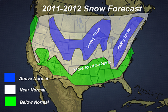
With the departure of Joe Bastardi, it looks like Henry Margusity may be the new go-to-guy for long-term winter weather forecasting at Accuweather. He just posted the snowfall forecast map above with his preliminary call for the winter of 2011-2012. Obviously it’s a long way off, but we like the way it looks. An excerpt from the full forecast:
“The basis of the forecast is on the prediction that a weak La Nina will be forming this fall and continuing through the winter. While the pattern will be similar to last year, there will be changes in the pattern that will lead to the heavy snow areas shown on the map.
I am not convinced that blocking will be prevalent across Greenland this winter, however, with the trough axis predicted to be in the Midwest, that will lead to storms developing along the East coast and racing northeast. The cold will be back in the Appalachians, and that will lead to heavy snow in that area. The major cities will probably be fighting many mix precip storms with the snow lovers along the I-95 corridor pulling their hair over heavy snow versus ice and rain.”


I don’t like to put a lot of stock into these long term forecasts, but I always do get excited when I see “Heavy Snow” over the northeast. We were considering a trip to Tahoe this year, but after looking at this, and seeing that it may be another La Nina, which typically favor interior BC, we may need to consider a return to Whitewater.
Harv, Thanks for find this stuff, can’t wait to get back in the snow mode..
Without a Greenland block the NE doesn’t see heavy snow and prolonged cold. Storms from the the Midwest will track up the St Lawrence.
Two winters are never the same, so it should be fun to see it unfold..
The biggest problem this winter is facing is, I bought a Subaru. This might be the kiss of death.
I rarely trust the five day, so, I’m supposed to rely on this stuff? Kinda arrogant, in a way.
Hey nobody said it was weather forecasting, it’s really viral marketing, but it is fun. The map above was posted on hundreds of websites within a few hours. I like to post this stuff so I can look back at it and see how it all panned out. Bastardi used to give an indication of temp and precip which I though was better.
Well, this reminds me of why I have problems with global warming science. A lot of those numbers are based on what is a relatively short period in weather history, ie, the last century when we were actually recording them. And yet, some weather scientists feel justified to use that data to forecast a hundred years into the future. God laughs at the arrogance.
We can only hope he is correct. One things for certain, we’ll be out skiing no matter what! Harv, looking back at last years forecast and the actual winter how did the long-range forecast hold up?
Oh, by the way PDQ I’m in! (as if you didn’t know that)
Harv: I suspect we hear about “heavy snow” every year from Accuweather about this time. They like to get people frothed up about a big winter, which often does not come to pass.
If storms are forecast to head up the St Lawrence this year, that usually means mixed precip if not rain to NE ski country.
A storm track in that direction typically blocks cold air from Canada… am I correct, Jason the Weatherman?
Generally it means most of the NE is on the warm side of the storm, unless there is some coastal redevelopment. That usually shuts off the southerlies, areas of Northern NE do well from this scenario.
A Greenland Block forces cold air from Eastern Canada into the Eastern U.S. Lets hope for a strong Greenland Block this season..
Thanks Harv, this is the first place I saw the Margusity map this season. The weak Nina seems to be a common thread for the ’11-’12 season; there’s a nice long running discussion about the upcoming winter in the New England regional forum at Americanwx.com for those that want to read more. They started it up back in April and in the first post, Will’s (ORH_wxman) thoughts were indeed weak Nina.
To me it seems foolish to attempt a winter snowfall prediction until October at the earliest. Until you can see how much snow and cold starts to build up in the high latitude source regions, you’re truly grasping at straws. At this point, that map is a pure snow lover’s fantasy… which I hope comes true 🙂
It doesn’t look like Henry is calling for a storm track up the St. Larry Valley. When there is mixed precip in the northeast corridor, that’s a coastal storm track which should put most of us in our happy place (if you discount the drive to the mountains). I also seem to recall weak Ninas being a good thing.
@Darrin – with regard to the foolishness of forecasting this far out, like many other forms of foolishness, it sure is fun. I promise you this, anytime I find a map with the words “Heavy Snow” printed on top of New York State, I’ll post it!
And oh yea, I’ll expect your winter forecast on Adirondack Weather Site on the first of October!
Sounds good. Hopefully true. I’m one of those hoping for the next Ice Age instead of global warming.
After a few hot days in early July, looks we are now on a slide to an early fall.
I do snow removal and look @ this to see what my contracts are going to look like this season.
When do you think the first snow fall will be and when will it stick in central new york?
That’s a ridiculous question, however, I will say that I am planning on skiing around Nov 12th at Killington, weather permitting of course. They typically try to open by then. NY won’t have skiing until closer to Thanksgiving if the weather is good. Bring it on!
Brring it on! brrring it on! BRING ON THE RAIN!
This forecast was about as wrong as a forecast can be, wasn’t it.
We never had a Greenland Block, Hence the warm and snowless winter..
A couple weeks ago, I was going to point out what a complete fail this forecast was, but figured that it was just pointing out the obvious — these things are just darts thrown at a board. While blindfolded.