
For many skiers, the season in New York ends sometime in March. For those a bit more passionate about the sport, some may make the pilgrimage to the more elevated resorts such as Whiteface or Gore, which usually spin their lifts until around the second half of April. And, for those who just can’t let the amazing NY season end, we find a way to continue making turns through May and even into June (if you’re crazy enough).

Whiteface’s Skyward, which sits at over 4,300’ in elevation at its top, usually holds a decent snow patch that is hiked and skied for a good couple weeks into May, eventually becoming too sparse and rocky by the time the Veteran’s Memorial Highway opens in the middle of the month.
There are a couple other High Peaks that hold a considerable amount of snow through the Spring, including Algonquin (5,114’) and Haystack (4,960’), but the snow patches are normally meager and not worth the muddy hike to get there. With the strong westerly winds we had this winter, much of the snow was dumped onto the eastern sides of the peaks.
When we skied Mount Marcy (5,343’) back in March, the “Snowbowl” on the mountain’s northeast side of the summit cone probably had well over 20 feet of snow. This patch of snow lies at about 5,200’ in elevation. Combine that with its depth at peak season and it can take a very long time to melt away completely. I would bet it’s the last snow in New York every year. The patch has been slowly shrinking every week with the increasingly hot temperatures as well as the absurd amount of rain we had for May, so I figured June would be a nice official send-off to my ski season, a rarity for most in the Northeast.
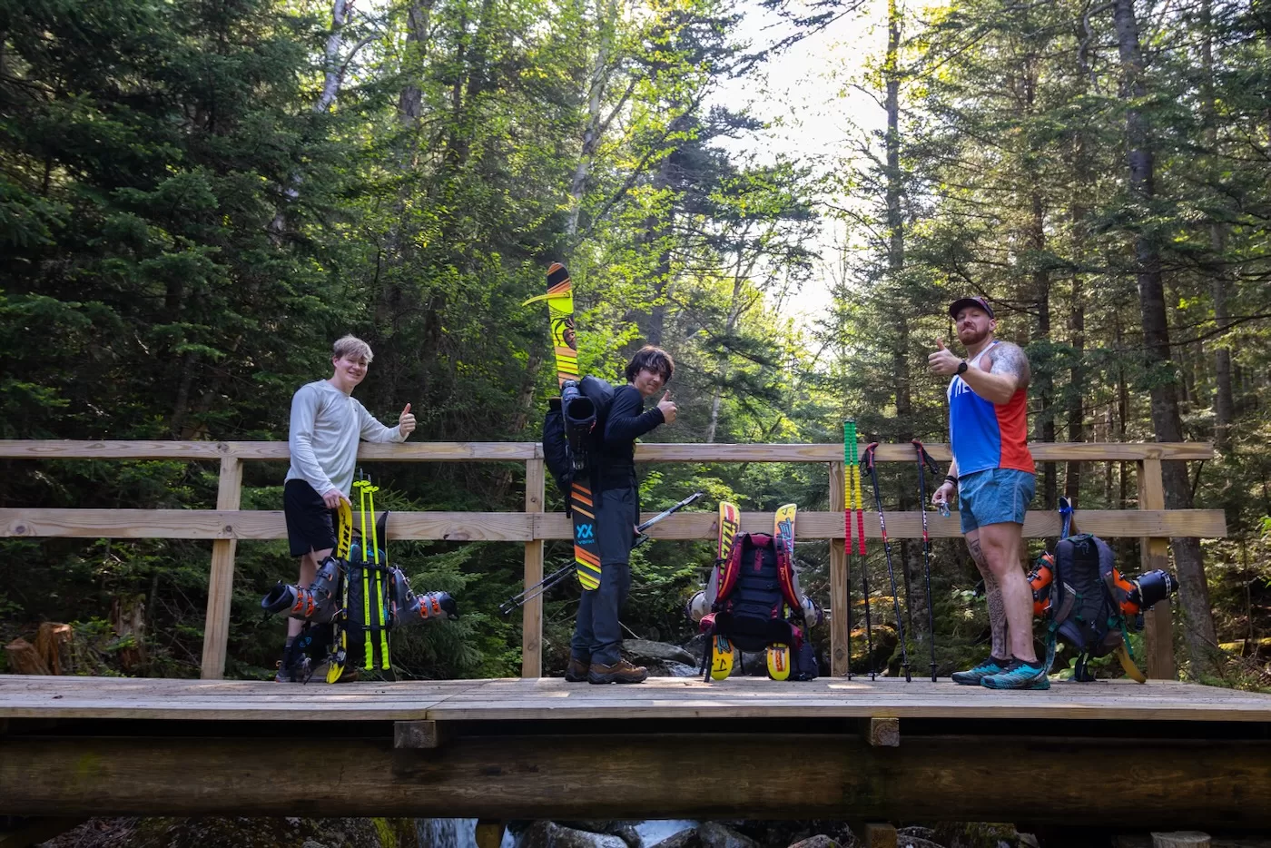
The day started at the Marcy Dam Truck Trail trailhead on South Meadows Road. The night before, my friend and Dry Hill local Kyle, brother Bailey and I camped at one of the many campsites along the road. It’s a nice spot that we frequent every summer because the trailhead is just a short walk away.
The plan was to meet Chuck and his girlfriend Natalie at the trailhead around 7am. Our friend and Gore Mountain aficionado Will was also joining us on a hike for the first time. In fact, this was going to be Kyle and Will’s first time on the top of New York’s highest peak, so even if the skiing was lousy, at least it would be an experience to remember.
Once we met up, loaded our skis/boots on our packs, and shared our excitement for the day ahead, we set off down the timidly-graded Truck Trail at 7:20. Although this route is a full .5 miles longer to Marcy Dam than the usual route from the Loj, it takes about the same amount of time due to being mostly flat and wide for rescue vehicles to take to the dam in times of emergency. It’s also much less traveled and muddy than the popular route, so I much prefer it.
It was sunny, without wind and the temperatures were in the low 50’s. The forecast said the summit would reach well into the 60’s later, so I wore shorts and a t-shirt without even bothering to pack anything else but a hat, sunscreen, food and water.

Within 50 minutes, we reached Marcy Dam and took a short break to enjoy the view. The popular backcountry ski haven the Angel Slides had water running down its slabs as the sun reflected off of it. I could see Colden and its summit in the distance, but the haze from the Canadian wildfires made everything a bit flat, lacking in contrast.
There were a couple other groups of hikers also enjoying a break, and as some passed us on their way towards Marcy, they gave us looks of bewilderment with our skis on our packs. Some even asked, “Are you really going skiing?” to which Kyle replied “ Yeah, on a dirt patch 5 miles away.”
We started back on our journey at a good pace towards Marcy, and from here would be the same route that we took back in March. Within a couple minutes, we crossed Phelps Brook by hopping from rock to rock as the clear water wriggled around us, an ice bridge a few months ago. The trail was somewhat wet and muddy from all of the rainfall from the previous month, but nothing our hiking boots couldn’t handle.
It wasn’t long after until we reached the bridge that crosses the brook again, about 90 minutes into our hike. We stopped for a water and snack to refuel for the steeper section ahead. It was at this point that my shoulders started to feel a bit sore from the weight of the skis on my pack. Thankfully, it wasn’t as much as a normal ski would weigh because my brother, Chuck, and I decided to bring ski blades while the rest of the group had normal touring skis, which are considerably lighter than the average downhill resort ski but still a pain to lug around on your back.
After the short break, we began moving again and within minutes came across the ski trail that we took last time. Of course there was no snow, only a winding route of ferns. The hiking trail nearly adjacent to the ski trail is a steeper section with many rocks and a couple switchbacks, which makes me much prefer the ski trail instead. A little over 2 hours into the hike, we reached Indian Falls, a popular rest spot for its views and abundance of water.

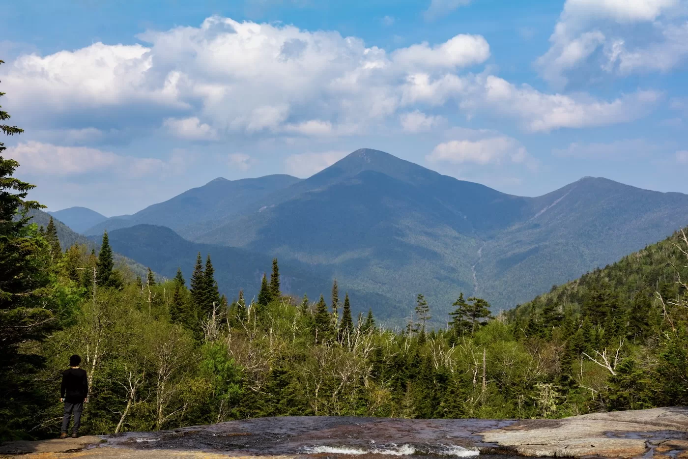
We rock-hopped over Marcy Brook and sat down at the viewing spot to take in the MacIntyre Range, which included from right to left: Wright Peak, Algonquin, and Iroquois. Algonquin, being the second highest peak in the park, only had a speck of snow on an eastern depression just off the summit we call “Danny’s Poop Chute” named after our friend Jack’s dog. This speck of snow was probably the size of a mattress, much smaller than the patch we were going to encounter on Marcy.
At this point in the trip, we were about 5 miles in and feeling good. Since it wasn’t blistering hot, the bugs weren’t out, although my hat was still covered in Deet just in case. From past experience, the next 2 miles of trail always seems to take forever and is quite a monotonous stroll through the alpine forest with a couple steeper sections thrown in there for good measure.

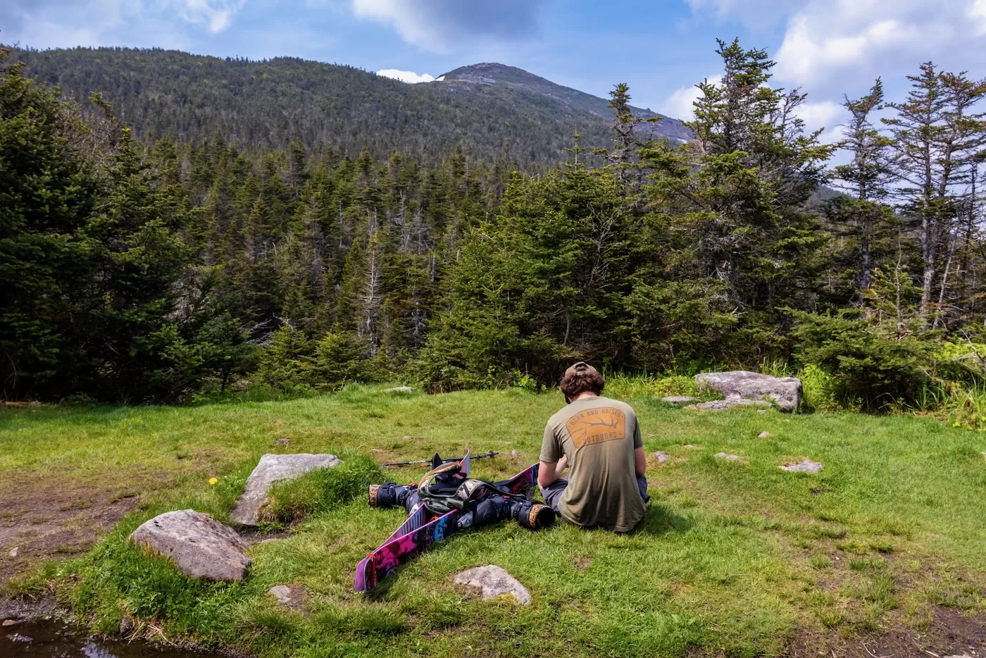
We pushed through this part without any water breaks until finally reaching a much needed rest spot that’s a small grassy field with a nice view of the summit. Off to the left of the summit was a glistening white patch of snow contrasted by the dense krummholz that blanketed the top of the mountain. This patch was all that was left over of the Snowbowl and was the reason we were hiking over 7 miles.
Fueled by the sight as well as some electrolytes, we really pushed ourselves the last half mile to the summit. This section of the trail can be very steep in places, especially once above the treeline where we scrambled up rocks, a much precarious route compared to the relatively flat skin to the summit in winter.
The last time back in March, the winds were so strong that we were nearly getting blown over because of the skis on our backs, but this time there was very little wind, just enough to keep the bugs at bay. After being greeted by a summit steward in flip flops, we finally made it to the top at 11:40 and celebrated Will and Kyle’s accomplishment over some venison and poptarts.

It was calm on the top of New York, but warm enough to sit comfortably in shorts and shirts. We weren’t alone as there were multiple other parties also enjoying their summit snacks and taking in the grand views above it all. The haze from the wildfires was there but wasn’t awful as I could see all the way to Lake Placid and could barely make out the outline of Whiteface in the distance. On very clear days, I’m usually able to see Gore, Mount Mansfield, and even Mount Washington way over in New Hampshire, but the view of the rest of the High Peaks is more than enough for a moderate 4 hour and 17 minute hike. I didn’t see any snow on any other peaks, although I’m sure there’s still some rotting snow deep under talus fields in Elk Pass or near Avalanche Lake.
After a lengthy rest on the highest point in the state, it was time to ski. We hobbled down across the summit and off the hiking trail, being careful to “do the rock walk” and avoid any fragile alpine plants like the steward advised. Within minutes, we were on top of the snow patch.
From above, it seemed to be about half a football field in length, which was more than enough for us! While getting our ski socks and boots on, a party of hikers gave us some words of encouragement and said they were going to hang around awhile to watch us make a lap or two. Being June, in summer fashion I took off my shirt, donned my bucket hat and sunglasses and lathered up in sunscreen. Everybody else was also scantily clad in not much more than shorts and sunglasses.

With much excitement we all watched as we made our way down one at a time. I began my descent, making shorts turns with my ski blades down the soft corn snow. Within a few seconds, I was at the bottom. A short lap, it made the whole journey worth it. We skied in June, in New York! The others headed down as I set up for photos, some schussing it while others making wide turns to really take it all in. We were still skiing, and that’s all that mattered. The day was my 60th day of the ski season, which is laughable for some but tremendous for me considering the last two years I only got 34 days of skiing in. For Chuck it was his 72nd day of the season on skis.
By the time the last skier made it to the bottom, we were all ready for another lap, so we boot packed our way back up the side in the snow with our skis on our shoulders. On the way up, I noticed the very edge of the snowpack was surprisingly deep; probably reaching 3 feet towards the middle of the patch. With that depth, I would be willing to bet enough snow will hold into July in this spot. The summit temperatures in June rarely go above the 60’s during the daytime and can dip below freezing at night, which makes me think there could be a possibility of some July turns, but we’ll have to wait and see.

Back at the top of the patch, I could see a small crowd hikers sitting on a ledge watching and taking photos of us. We must’ve looked crazy to them, and we probably were. On the next lap I skied down about halfway and set up for shots of the rest skiing down with Haystack in the background. The deep contrast of the snow and the snowless peaks in the distance looked surreal through my camera lens.
They made their way down one at a time, hooting and hollering as skiers often do because it’s just too much fun. I then met them at the bottom and we decided for the next lap Natalie would stay at the bottom and get a video of all of the guys barreling down shirtless. Anything for social media right? We made our way back up, which only took a couple minutes of hiking each time. At the count of three, we plunged down the corn snow together, laughing as we got to Natalie and sprayed her with snow from head to toe.

At this point, the sun was bright in the sky and the snow wasn’t doing much to cool us off – not to mention the constant up and down was dehydrating us pretty quick — so we decided to do one more lap before calling it quits for the season. I chose to stay down towards the bottom, for this time I wanted to get a shot of the entire group coming down together. With my go ahead, the rest of the group made their way down together, smiles and all. Skiing in June was not on my mind when our season started for us back in October, but a 9 month ski season on the east coast is nothing short of phenomenal!
We skied until 1:30. We took off our ski boots, strapped everything back on our packs, and began our way back down the mountain. Admittedly, most of us were out of water at this point, so we kept a quickened pace and didn’t stop at any point until making it to Indian Falls a little over an hour after we began our descent. I used my water filter to fill up everybody’s bottles with the cold, refreshing water. The temperatures must’ve been in the 70s since we were all dripping in sweat from a combination of the heat and the exhaustion of hiking with a 20 pound pack.

After the water break we carried on without stopping down the trail until we stopped at a water hole near the Phelps Brook crossing. Natalie wasted no time in jumping right in the frigid water while the rest of us dunked our heads in. It was extremely refreshing and made the rest of the way back more tolerable than it would’ve been otherwise. We passed a couple more hikers that gave us funny looks or even wanted photos of us without skis on our backs while everybody else couldn’t fathom what was wrong with us.
We made it back to the trailhead by 5:15; four hours after leaving the summit. Our legs were covered in dried mud and my trail running shoes were wet. It felt so good for all of us to finally take off the heavy packs and massage our sore shoulders and backs. Without any wind, there were now bugs surrounding us, so we said our goodbyes and parted ways until next season. Being able to ski as much as I did this season was remarkable for me, especially the amount of powder I skied all over the state and across the lake. I couldn’t have asked for a better day to end the season. Now I’ll keep myself occupied with slide climbing while I await for the mountains’ first frost.
Some people talk about adventure, others live it. Kudos to your legendary crew.
Great trip!
What a great adventure to find skiable snow in June. I can’t imagine that hike with boots and skis on my back. Terrific pictures, thanks for sharing.
Epic story and amazing pictures. Props for getting after it like always. I’ll leave the June skiing to you and stick with my 2pm tee time. Cheers boys see you next season!
Beautiful!! thanks for the show! Y’all are looking good without helmuts while rippin’ turns down the last of the snow!
Fabulous account! I’m going to feel guilty the next time I get on a chairlift. Bravo to you and your crew!
Wow, this is some great stuff. I’m very impressed, can’t wait to see what you all get up to next. Thanks for sharing this
Now that is patch skiing done proper, with a 7 mile approach! Thanks
LOVE IT! Never wanna give up the ghost. Thanks for sharing, great photos! I might copy you next year with my metal edge xc skis (bc they are lighter and I am weaker, haha)
GREAT post. Not sure how many High Peaks my knees have left, this was great. You may be aware that an observer shared your exploits to the Adirondack Trail Conditions FB page.
Excellent trip! You should get this on Snowbrains site. Great PR for Eastern skiing, especially NYS Adirondacks.
I keep coming back to this epic adventure, Congrats on that journey, the memory will last for you forever. June 17 and skiing in New York, c’est Fantastic!