
Panther Gorge is a unique zone deep in the High Peak wilderness; it’s one of the most remote places in the park, and for good reason. Lying between the highest peak in the state (Marcy) and the third highest (Haystack), the Gorge is in a world of its own.
From The Garden, it’s about 7.8 miles; the Loj is 7.5 miles, Elk Lake is about 9 miles, and Upper Works is 10.7 miles, and these are just the distances to reach the area, without including exploration and a return to the trailhead. If you’ve ever hiked Haystack or Marcy and looked across towards the other’s peak, then you got a glance of Panther Gorge.
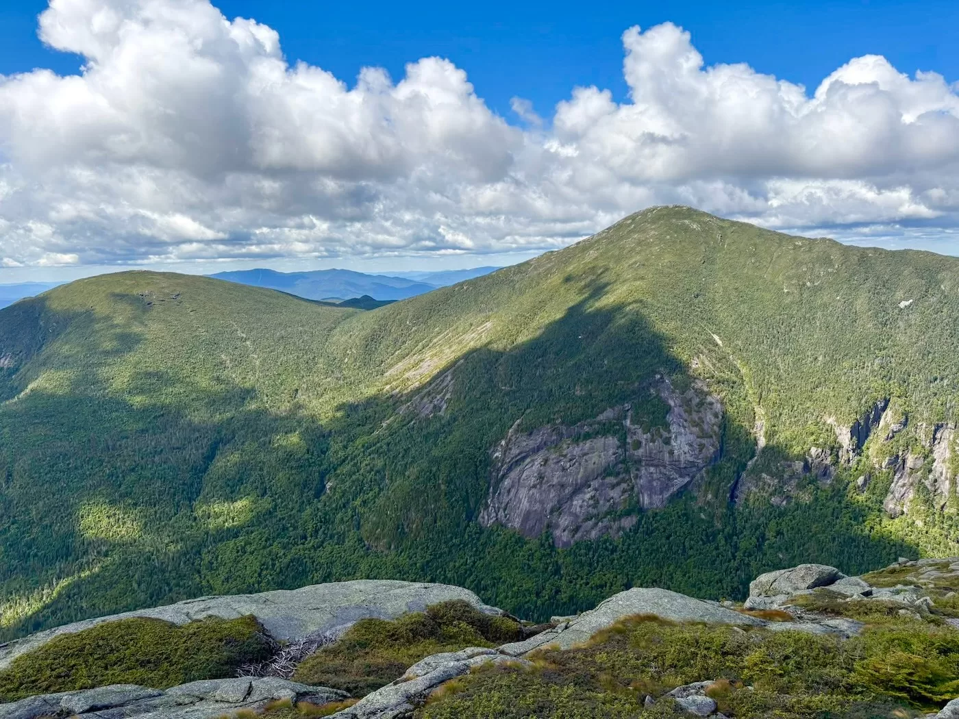
Dropping thousands of feet from the nearby summits, the Gorge’s floor sits at 3400’ and is roughly 200 acres consisting of beaver ponds, large talus fields, remote streams, and a trail-less alpine forest. The eastern and western sides of the void are flanked by cliffs that rise hundreds of feet, a mountaineer’s quiet paradise.
This glacial valley has been surveyed by many of the High Peak’s early explorers, including Orson Phelps and Verplanck Colvin. More recently, modern adventurers like Kevin “Mudrat” MacKenzie have made numerous outings to the Gorge and written extensive reports of what he came across, including the Mount Marcy Cavern, one of the largest talus caves in the northeast. There are a couple landslides that rise up the sides of the mountains, and with fall quickly approaching, I felt it was about time to do some exploring for myself.

When I think of slides in the Adirondacks, I usually imagine Colden, Giant, or Dix, each of which is littered with almost a dozen slides. Since I’ve climbed every major slide on each of those peaks, I need to look closer to find opportunities seldom discussed within the slide-climbing community.
That’s where Marcy comes in. Marcy has only two 4th class rated slides: a small, subtle slide dubbed “Grand Central” from backcountry skiers, and a wide, mature slide rightfully dubbed the “Old Slide.” Grand Central is on the smaller side, rising up from Panther Gorge on the eastern side of Marcy roughly 1,200 feet. It’s only 50’ at its widest section.
On the other hand, Old Slide lies on the southern side of the mountain, 900 feet long and almost 2,000 feet wide. After mapping out a route to reach both slides via the Gorge, we began our adventure.

The trailhead at Elk Lake is a popular starting point for hikers, especially those looking to conquer the Dix Range. The issue with this trailhead, also shared with the popular Garden trailhead, is that the lot can only hold up to a dozen cars. The overflow lot is over a 2 mile walk away, so if you don’t get there early enough then you’re adding another 4 miles onto your hike, especially on a Saturday.
With that in mind, my youtuber friend Brian, another friend and slide-climber Joe, and my brother and I met at the trailhead at 4am. The lot was already half full, likely with people camping in the backcountry. The car said it was 40 degrees but it felt a lot cooler. The sky was cloudless with a dark sea full of stars. It was the perfect conditions to start a long day of hiking.
After a quick briefing on the day ahead, we started down the trail towards Marcy. We donned headlamps since we wouldn’t see the sun for another 2 hours. The trail split left and right at multiple times towards other destinations, but we remained on our narrow path as it winded through the still forest.

Every stream that we crossed was dried up as New York and the rest of the northeast is currently in a drought. This restriction on our water supply worried us. Three miles into the hike, the trail began to crawl uphill and crest a ridge. Once we dropped along the other side, temperatures dropped significantly. We put on our jackets and gloves as it felt like temps were in the low thirties.
Gradually, the sky became brighter and the sun rose at 6:30. Soon after, we took a water break. Another half hour brought us to the Panther Gorge lean-to, where we sat down and took our first snack. Thankfully, Marcy Brook ran right down the trail from the lean-to, which had enough flow to fill us all up.
At this point, we were 9 miles in and about to enter the southern end of the Gorge. The brook was our direct lead into the heart of it, so we began to hop from rock-to-rock towards the north. The brook came to a fork shortly after, the left path heading towards the col between Skylight and Marcy, and the right path leading us deeper into the Gorge.

With ease, we continued to rock-hop up the narrowing brook, climbing over timber and jumping to the bank when necessary. Our first view of Haystack poked through the trees, its steep slope littered with colorful foliage mixed with dark spruce. Much of the foliage that surrounded us began to change colors.
I noticed some of the trees were cut, by beavers. There were a couple dams that crossed the brook, but due to the low water levels they didn’t really block much of anything. Through the forest, I could see an opening to my left, so while we took a short break I walked over to see what views it might hold.
Once I popped out onto the dry swamp, I was met with the immense East Face of Marcy. The cliffs and their pitches rose hundreds of feet upwards into the oncoming sunlight. To the north, I could barely make out Grand Central against the treeline. My excitement for the day was instantly reinvigorated, so after snapping a couple photos we continued along the brook.

The water became a trickle as we climbed in elevation. Checking his GPS watch, Brian announced it was time to leave the brook and head west to find the drainage to the slide.
After a short bushwhack, we came across a meager path of rubble filled with blowdown. We knew this to be Grand Central’s drainage, so we followed its winding path as it began to steepen. Not long after, it turned into a steep scramble right beneath a ridge of cliffs. As we approached them, we could see an imposing feature before us: Panther Gorge Falls.
The massive waterfall rises over 100 feet to the base of the slide. Unfortunately, we’ve been in such a drought, there was hardly a trickle coming down its overhanging walls. Still, we sat in awe beneath the falls, taking the moment to filter and drink our fill.

It was 8:30 am and the sun was well above Haystack at this point. After some debate, before we venturing up towards the slide, we decided to spread out and head north for a couple hundred feet in search of the infamous Mount Marcy Cavern.
According to reports, this cave has a large entrance and contains over 440’ of passages inside, which would for sure be the largest cave system I’ve ever been in. The exact whereabouts to this cave aren’t shared anywhere online or in any book, only general points of elevation and its proximity to Panther Gorge Falls, so finding it would be no easy task.
While the others stayed high below the mountain’s steep walls, I dropped down a couple feet in elevation to explore. Almost immediately, I came across a large talus slope filled with rocks the size of small houses. As I carefully stepped around the rocks to not fall between them, I peered down into some deep, dark holes, reaching close to 20 feet.

After we spent 30 minutes navigating around the talus, I could hear the others say they were heading back to the falls to recuperate and continue on our journey. I reluctantly also began to climb back up the dilapidated forest, while keeping my eyes out for any large openings in the earth. Although I found many smaller caves, some big enough to crawl into, none were even close to the size of the Cavern based on previous reports. Thus, I will surely be back to the Gorge another day in search of this seemingly-mythological entity.
Once we met up back beneath the Falls, I realized we had taken over an hour searching for the cavern, much longer than I had hoped. With Brian in lead, we hurriedly to bushwhack south of the falls up the steep slope to reach the bottom of the slide. What we thought was going to be a cake walk was anything but.
The slope was riddled with steep ledges and options far too exposed for comfort, so we backtracked to choose a new path multiple times before we were finally pleased with our decision. While still not easy, we scrambled up the rocky sides of the mountain, clinging onto branches and weeds as we made our way upwards.

After bushwhacking through moderately open woods for a couple minutes, we came out onto the slide maybe 50 feet above the top of the waterfall. Haystack loomed high in the distance as we began to walk up the timid rock. The slide was mostly dry with smooth anorthosite slabs fixed about.
Little did we know that this would be the most enjoyable part of Grand Central, because after about 10 minutes of climbing, the slide shrank into brush as the vegetation had swallowed the path ahead. I pulled myself through the bushes and grass with anticipation of it opening up again. Thankfully it did, but not what I expected. The slope of the slide increased as it began to twist to the south, but what lay at our feet wasn’t slab but none other than my arch-nemesis when it comes to slide climbing: rubble.
As we were scrambling over the grapefruit-sized boulders, Joe dislodged a sizable one above me. He shouted “rock” as it came crashing down in my direction. I lurched to the right as it barely passed by me, tumbling all the way into the brush below until we didn’t see it anymore.

I don’t like climbing over rubble. In addition to the bombs dropped from above, rubble moves below your feet with almost every step, as Brian put it “two steps forward, one step back”. Exhausted, we pushed forward to the top of the slide, exactly 11 miles from when we started about 6 hours earlier. We all agreed that the slide wasn’t the best we’ve seen, but it was fine since it was only a minor highlight to the day’s adventure.
After a much needed lunch break, we had a fierce bushwhack ahead of us, so into the trees we went. Our next objective was to head over to the top of the Old Slide on the south side of Marcy and descend back to the trail. Based on our GPS, we had roughly .3 miles of thick bushwhacking before we reached the slide. Although we weren’t high enough in elevation to run into the impenetrable krummholz most often seen near the summits of the peaks, the going was anything but easy.
As we bushwhacked in a line, the person ahead of you would disappear if they got even 10 feet away from you, so we constantly called out to each other to make sure we stuck together. Plenty of times the only option forward was crawling on hands and knees, a slow but necessary process.

Within 15 minutes, we had made our way onto a ridge full of cripplebrush where we were given a view of the summit. From here, we began to head slightly downhill on course for the slide. To our surprise, the woods began to open up a bit around 4650 feet. We were able to quicken our pace until reaching the top of the Old Slide, 45 minutes from when we left the top of Grand Central. Our appetites grew during the strenuous ‘shwack, so we shook the pine needles out of our shirts and enjoyed lunch with fresh views of Skylight.
From what I’ve read, this slide is aptly named since it’s theorized to be hundreds of years old. There was vegetative growth all the way down to the bottom, thankfully only in clusters so we could still enjoy some rock to descend. In the distance, through the haze, I could see Macomb Mountain with all of its rubble slides, an expedition I have planned for next summer.
In the foreground, Pinnacle Ridge looked like the back of a disfigured dragon from our angle. Haystack sat to our left, and Skylight to our right. We could even make out small figures moving above the treeline heading towards the summits, and I wondered if they could see us.

The temperatures were now into the 60’s and a slight wind blew as the sun was high above us at this point. It was the perfect conditions to sit atop the slide and soak in our last views for the day before the long trek out.
Although it was only noon, we were anxious to get back to the trailhead as we were all hiking the following day. We finished our lunch and began to walk down the rock. The start of our descent was all flat slab not likely exceeding 40 degrees, but it didn’t cause us any issues since the surface had decent grip. There were a couple steep ridges towards the middle of the slide that required us to crabwalk down.
The bottom of the slide maintained the same pitch as before, and within 10 minutes we reached the end of the rock. Looking back up, I could see how far this slide stretched left and right as we only explored a small section of it. The next time I’m back, I plan to be on skis to check out more of the terrain.

A short bushwhack ensued until we reached the trail just above the Panther Gorge leanto from earlier in the day. The time was only 12:30 but we had over a 9 mile hike back to the trailhead. Now that we were traveling in the light, the trail seemed to meander for much longer under the colorful canopy than it did in the dark.
Full of electrolytes and gummy candy, we still had a lot of energy, so our pace was nothing short of 3 miles per hour. In fact, when we only had half a mile left to go, we decided to jog the remaining trail to speed things up a bit. After nearly 11.5 hours and 21 miles, we were back at the parking lot.
Looking back, although it was unfortunate we didn’t find the Cavern, being in Panther Gorge felt surreal. I know that I’ll return to explore it more!
What a wonderful adventure. Thanks for posting. Looking forward to your outing next summer with descriptions of the cave. Why do you describe it as “infamous”?
Hey Richard, I say it’s infamous as more of it’s hard to find, not to put it negatively. Only a handful of people have ever found it and explored its depths. Hopefully next summer!
Thank you for sharing. Great read.. Nice work
Damn that’s impressive. Another great adventure. I bet you guys all slept pretty soundly after that one.
Great story and stunning photos. Keep after it!
Really enjoyed this. Awesome write-up, sounds like an excellent adventure!
More places I have planned to be but haven’t yet. Following in your footsteps I tried to find Moose Mt. Slide again. I definitely know where it isn’t! Thanks for these nice reports. I find them very inspiring…