
Hook Mountain State Park, together with the adjacent Nyack Beach, Rockland Lake and Haverstraw Beach State Parks, is one of my go-to local recreation spots. The Mountain itself is about 700 feet tall and part of the Palisades, a string of cliffs along the western shore of the Hudson River that begin further south in New Jersey.
In the past I have used it more as a spot to launch my kayak into the Hudson or to ride my bike but this year I decided to spend more time hiking there instead, as a way to improve my endurance and overall fitness — sort of a challenge to step it up a bit.
There are a number of hikes to chose from there. The most popular is an up and back from Nyack Beach to the Hook Mountain summit. From Nyack Beach, you follow a white-blazed trail up a series of switchbacks and a long gradual southwesterly climb until you reach The Long Path, marked by aqua green blazes.

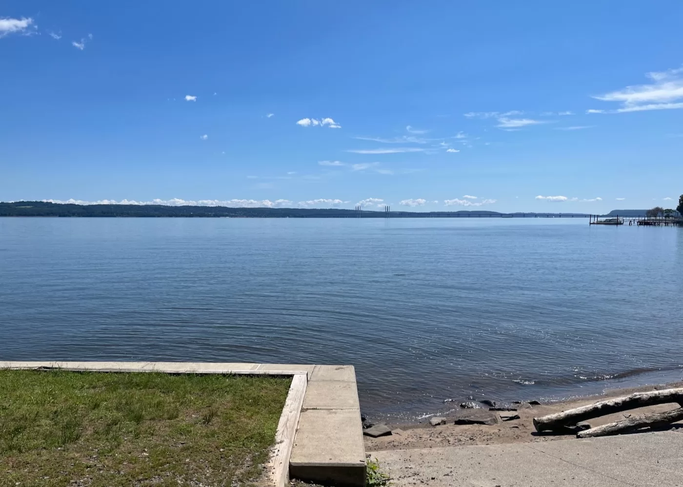
Following the Long Path north brings you to the top of Hook Mountain. Up and back is under 4 miles and takes an hour and a half if you don’t dawdle. This is a pretty cool little hike. The payoff is taking a gorgeous view of the Tappan Zee and surrounding area.
A little more ambitious — and the route I’ve repeated most this year — is to go from Nyack Beach up to the Long Path and then take that all the way up to the Rockland Lake Firehouse, where you can descend to a bike path and follow it back south along the Hudson to your starting point.

This loop is just over seven miles and, after a bunch of ups and downs along the ridge, gets you about eleven hundred feet of vertical. It takes me between two and and three hours. You get more exercise, some nice views of Rockland Lake, Croton Point, the Hudson and lots old ruins in the woods, remnants of when quarries and the Knickerbocker Ice Company monetized the Palisades’ natural resources with a vengeance.
Hikers don’t have to turn around at the firehouse. The Long Path and the bike path both continue to the north from there. I had never done this portion before this spring (just wasn’t on my radar). On a rainy Saturday this past April, I parked at the firehouse and headed north instead of south on the Long Path.

Right after starting out, I came across an old family cemetery. It is very old and the grave markers are missing or too weathered to read but a sign by its front gate — put there as an Eagle Scout project — identified it as the Wells family plot and detailed who was buried where. As an aside, Eagle Scouts have done tons of good in this area. There are infographics, mile markers and other projects all around with different kids’ names on them. The trail maintainers have done great work too. Everything is impeccable.
From the cemetery, you climb up onto the ridge and follow it north. It was obvious that this portion gets less traffic than Hook Mountain. I think I only saw one person until I was back on the bike path for the return loop. I had a little route finding drama that first trip. I knew that there was a trail down to the Haverstraw end of the bike path but I missed the turn and ended up on Route 9W.

This wasn’t that big a deal, even though I was now on the wrong side of a freight rail line that paralleled the river there. There was a historical marker for Snedeker’s Landing that I’ve driven past a thousand times and a gravel road just to my right. I followed the gravel path eastward and, after some poking around I found a tunnel under the tracks and down to the the bike path. I walked back to the firehouse via the bike path- another successful adventure in the books. According to Strava, I’d done almost eight miles and, surprising to me, almost the same vertical as the Hook Mountain loop. There were a lot of ups and downs.
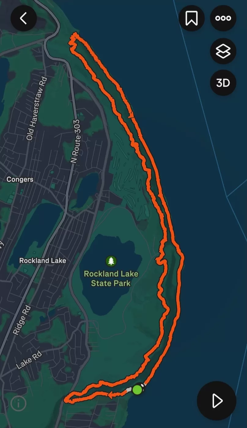
Since then, I’ve done the Hook Mountain hike a few more times. My goal was to put it all together and hike the full length of the ridge. Based on my past Strava data, I thought it be around fourteen miles. To that end, I’ve been paying more attention to my exercise routine this year, getting to the gym more, taking long walks around town or on a nearby rail trail. Finding time to fit more than that into my schedule was challenging. By the second week of August, I decided to just do it. On Saturday, I got up early, headed down to Nyack Beach.

At the gate, the park ranger checking me in mentioned there were a bunch of runners there already, doing a race. Interesting. When I made it to the parking lot, all there was to indicate anything special was a single unattended canopy with some coolers and bags underneath. I parked and, with three liters of water, some Kind bars and extra socks in my day pack, I headed up the trail.
I moved fast on the first section up to the Hook Mountain summit. Getting all that climbing out of the way boosted my confidence some. I paused to catch my breath and take a couple pictures. There is a small exposed summit and the trees that grow around it are short and stunted in the way you expect to see at much higher altitudes. The view really is impressive. As I was standing there, two guys came charging up the trail, glanced at the view, nodded to me and kept going. Yup, there’s a race today, I thought.

Once I’d caught my breath and sipped some water, I moved on, following the aqua blazes north. Once up on the ridge, the path is a bit more fun, snaking back and forth. In some places it drops down into a saddle and then climbs again, weaves through the trees in some spots and in others treats you to more views of the river.
A couple more trail runners overtook me. I paused for a snack and a rest, then kept on. The trail eventually settles into a more gentle track along the eastern side of the ridge, in places following the path of abandoned roads. In other places there are are old rock walls and the remains of old buildings, harkening back to commercial ventures long gone. There is lots to explore in these woods but I was on a mission so I stuck to the trail.

It was hot. The miles accumulated and I started feeling it in my legs. I contemplated turning back at the firehouse and just doing the seven mile loop but as I began to hear the sounds of families picnicking at Rockland Lake, I felt better. By the time I picked my way down to the firehouse, I’d resolved to push through and hike the whole route.
Up past the Wells family cemetery, I moved with purpose. My good attitude lasted awhile; then I was doubting myself again. None of it was really steep but the relentless ups and downs and the heat took a toll on my middle aged body. My legs felt like rubber. I considering texting somebody to pick me up in Haverstraw but shame stopped me. Then I thought about bushwhacking a shortcut down to the bike trail but it would have required finding my way between the high rock faces that make up the Palisades. The prospect of getting cliffed out and having to climb back up dissuaded me.

More runners went by; at least they moved slower now. Then a woman coming the other way asked how many of us there were running today, thinking I was part of the race. That’s funny, I thought. I told her I’m not racing — just ended up in the middle of it by accident. Me too, she replied.
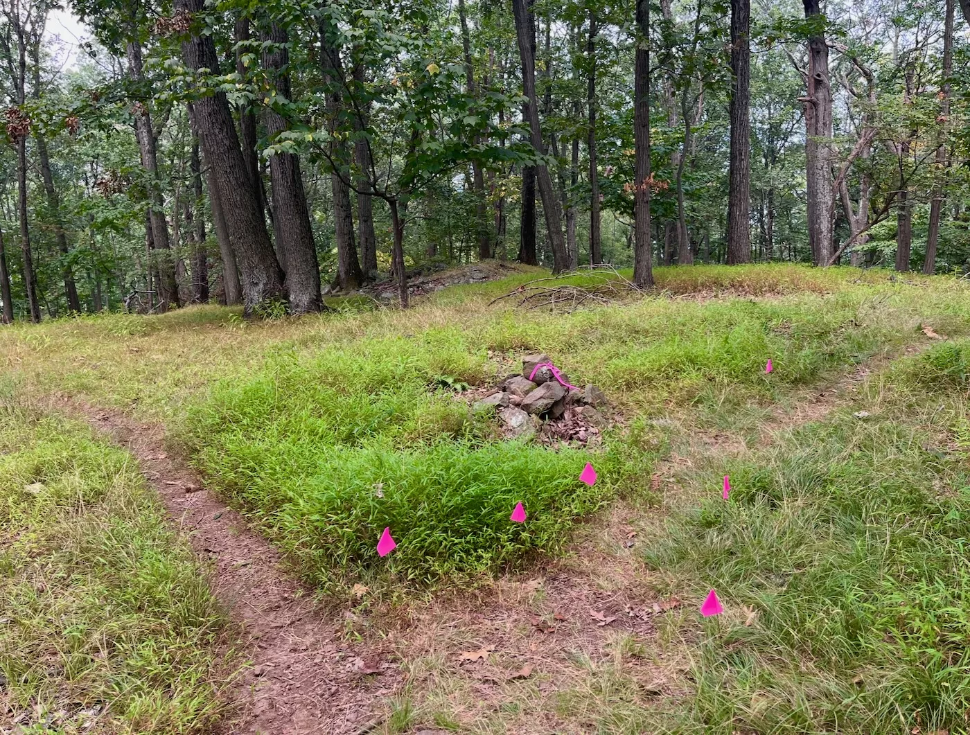
Then I got a break. Whoever organized the race had marked the switchback trail that led down to Haverstraw Beach State Park with pink ribbon, recognizing that it was easy to miss I guess. I looked down and recognized a low crumbling cairn with two faded, almost gone white blazes. I turned and could pick out a faint trail and a few white blazes and tons of pink ribbon. After another brief stop for a snack and more water, I descended one steep, narrow switchback after another, by far the gnarliest part of the trip.

Soon enough, I made it to the bottom of the switchbacks and emerged onto the bike path, right across from the ruins of an old building I had biked, walked and XC skied past many times. Stepping onto the crushed stone of the bike path felt like my return to civilization. A dad and child flashed by on bikes. The hard part over, I was still over four miles from my car.
Those 4 miles were easy bike path miles but I was shot. I walked slow, took more breaks, fueled up with another Kind bar and the last of my water, and eventually made it. Strava recorded it as 13.14 miles, 2,168 feet of vertical and 29,160 steps — not exactly ultra runner stuff but the furthest I’ve walked in a really long time.
Great adventure. Enjoyed the photos.
Thanks for the in-depth lesson.
I walked that trail a ton.
Never thought about the history.
That looks like something that I would enjoy. Think I’ll plan a day in September. Thanks for the information and pictures.
Good push! Cool pics and story. That will be a hike on our radar now. Your ski legs will thank you for your effort ===”
Great story, Brownski. Plenty of places to get outdoors in the NYC metro area if you look around a bit.
Nice loop, Brownski. Way to push through and connect the dots.
An interesting aside about sharing this on the Skiblog……the origin of the Long Path (1931) was the same Vincent J Schaefer who along with members of the Mohawk Valley Hiking CLub (1929) and the Schenectady Wintersports Club (1932) that established the first Alpine Skiing on Yantaputchaberg, the highest mountain (1,300′) in the Mohawk Valley. SWC built downhill runs for different skills, including a popular racing trail, pioneered metal edges on skis, and petitioned locals to support the Snow Trains that eventually ran from Schenectady then Grand Central Station to North Creek’s Gore and Pete Gay Mountains in the 1930s, until WWII. Their efforts were responsible for the start of the multi-million dollar Ski Industry in New York State. BTW if you continue on the Long Path you eventually will end up atop Whiteface Mtn (Whiteface Ski Resort) the northern terminus of the LP.
Nice report and great hiking Brownski. Nice to read about you putting the entire loop together. Pieces of this are my local go-to spots for hiking or walking my dogs. Great read – thanks.
Great write up! I live in the area but didn’t know about the switchback back down to the bike path near Haverstraw.
Nice job finding adventure (and a great workout) close to home! I enjoyed the write-up and pictures.
Nice looking hike. I do love the river view.