
The Adirondacks are unique in many ways. They’re rugged, dismal, rocky, muddy, densely populated with spruce trees, and most are miles away from any trailhead. One thing that I think truly sets them apart from other mountain ranges in the East, or the country at that, would be their magnificent landslides.

While almost completely lacking in Vermont and Maine, New Hampshire has a fair share of slides that are frequently climbed. However, most are very different from the slides we have in New York. They’re usually small, full of rubble and dirt with minimal slab, while the slides of the Adirondacks are beautiful streaks of smooth anorthosite that can rise hundreds of feet wide and long up a mountainside.
They also form much more often here, typically occurring during a heavy rainstorm that drops multiple inches of rain in just a few hours. The thin layer of soil becomes too heavy to stick to a steep slope, so gravity ends up pulling it down, leaving behind a white stripe of bare rock.

On July 13th, a short but powerful thunderstorm swept through the High Peaks. My brother and I were on our way back home from Whiteface when the sky turned dark and pounded us in a burst of heavy rain. It was over in under an hour, but the “damage” was already done. The next day, the DEC sent out an advisory that multiple landslides had occurred within Avalanche Pass and on the backside of Mount Colden due to the heavy rain.
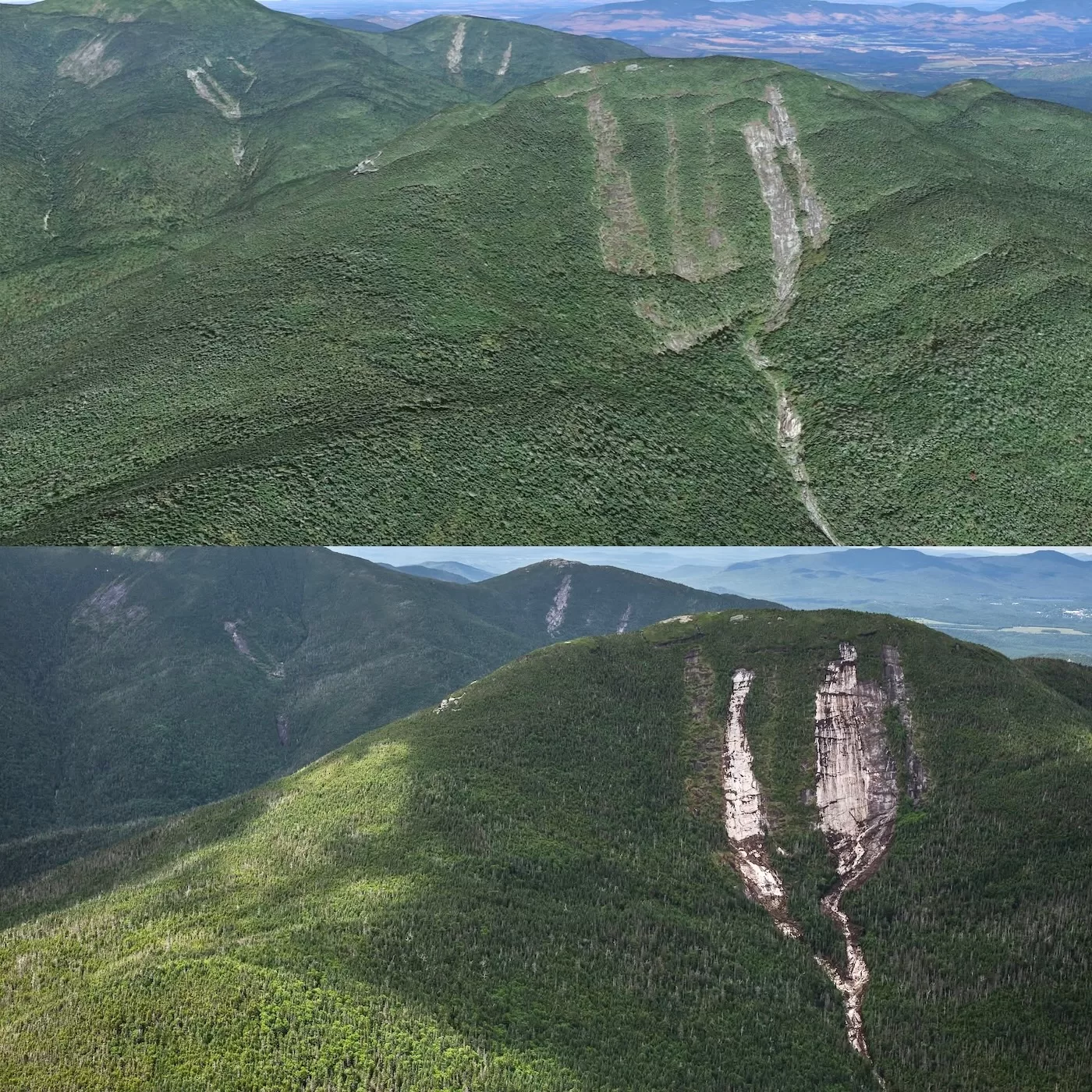
Oddly, although minor slides occurred in other places around the High Peaks, Mount Colden was the most affected, three new slides formed and many other reslid or were widened. This was likely the result of a microburst, which forced heavy rain and wind down within a localized area, Mount Colden.

Avalanche Pass Trail was heavily affected by the mud and debris piled up at the base of one of the new slides, named the Jackson Slide in remembrance of the late Forest Ranger Brendan Jackson.
The trail is closed to all hikers while DEC Rangers assess the damage and condition of the area. Another one of the new slides — and the largest of the 3 — formed on the northwest flank of Colden next to an older slide named West Ramp, a popular backcountry ski destination. Although there was a lot of debris at the base of the slide, it didn’t directly affect any trails. I’ve never climbed a slide less than a week old, so that was the mission for the following Saturday.

With Avalanche Pass closed, the next most efficient way to get to Colden is from Upper Works, a parking lot near Tahawus with multiple trailheads. My brothers Bailey and Riley joined me for this journey, along with Riley’s friend Devin. Two ski companions Chuck and Will also joined us, who accompanied me to Marcy in June.
We met up at the parking lot at 7am. It was sunny, temperature was in the 40s, forecast to reach the 80s later in the day. After making sure I had enough water and electrolytes, we headed off down the Calamity Brook Trail towards Colden. The trail, while long was very moderately-graded and never rose above a gentle incline. Some parts were a bit muddy, but there were many boulders strewn about that allowed me to keep my trail runners dry.

After almost 2 hours of fast-paced walking, we arrived at Flowed Lands, a large marsh with a far away view of the slide we were after. After short water break, we continued on the trail that skirts around the marsh to the north until we came upon a bridge at the foot of Lake Colden. Again, we had a grand view of the new slide across the water; its white rock greatly contrasting against the shadowed forest.
The water was brown compared to its normal color, most likely due to the recent rainfall and all the mud that spilled down from the mountainsides. From here, we crossed over the bridge and headed north on the east side of the lake that eventually leads to the base of Colden. I figured once on the slide, we wouldn’t find a water source again until we were off the mountain, so the others and I filtered the muddy water into our bottles, which although looked clear once filtered, had an earthy taste to it.

Within a couple more minutes of walking, I could see a clearing in the forest to my right. My GPS confirmed that that was where the debris pile should be from the new slide, so a short bushwhack led us through a wall of blowdown and onto the muddy drainage below the slide. Boulders were everywhere, ranging from the size of a basketball to the size of a small house. The mudslide event had pushed all of the forest out of its path and either covered the trees completely or thrown them to the side.
Some of the thicker trees still stood at the sides of the drainage, while others were snapped in half. The coolest sight to see was the height that the mud had reached during the event. On the surrounding trees that still stood, dried mud covered their trunks 20 to 30 feet high, which just paints a picture in my mind of how forceful Mother Nature was that rainy night.

Looking up at the slide, the base of it was a cliff with many ledges. Although they looked tempting, the ledges were still covered in mud, trees, and other debris, so our next option of ascent was to bushwhack in the steep trees next to the slide until it was level enough to exit the woods. This proved to be arduous as expected, especially higher up once the forest thickened.
During our bushwhack, we came across a small slide that must’ve also formed from the storm since there was fresh blowdown at its base. We scaled it, a little teaser of what was to come.

An hour later, we popped out onto the slide beneath a wet ledge that we carefully traversed. This slide, West Ramp, wasn’t the new one, but needed to be crossed to get to it. As previously mentioned, West Ramp is a popular backcountry ski destination due to its length and perfect slope. The rain event had widened this slide as well as took out many trees that were once scattered throughout the area, so I’ll be sure to put this one on my list to check out this next winter.
We decided to take another water break and admire the view before fully crossing over to the new slide. By this time, the sun was bearing down on us, so I donned my hat and glasses as well as put on my approach shoes for better grip on the coarse rock.

A short traverse on the low angle slide led us past a strip of trees and finally onto the new slide. I knew the slide was big from photos people took from Algonquin, but looking up the thing was mesmerizing due to its sheer length and width. Whereas most slides are either skinny, broken up by patches of vegetation, or covered in dirty lichen, this slide was almost so white it seemed to glisten in the sunlight. This was partially true, since many minerals had been freshly exposed that were once hiding underneath the landscape.
Looking down the slide was a bit nerve-racking since it seemed to just drop off maybe 100 feet below us. Of course, we had nothing to worry about as far as traction went since the rock was so uneroded I’m sure any fall would just result in a bad skin scrape.

I quickly measured the angle of the slope, roughly 27 degrees, although I knew it would increase since the headwall looked much steeper from afar. We began our climb up the grippy 6-day-old landscape. Much like a backcountry skier might ascend a slope in a zig-zag fashion, I felt it easier and less tiresome compared to just walking straight up and having to catch a breath every minute, so I walked left then right, alternating every 50 feet or so until the last 100 feet of the slide.
For the most part, the slide lacking any ledges up to this point. Now ahead of me was a rounded ledge, scaleable but it required my hands since it was steep. Once above the ledge, the slide was a consistent 40-45 degrees, so we slowed our pace to make more careful steps and grab onto any outcrops in the rock.

The last 30 feet of the slide was wet due to the water seeping down from the trees above slide, so we opted to head back into the alpine after getting a final glimpse down the slide, and in my mind imaging how it would ski in the winter. We were on the slide for about an hour and it was almost 1pm, so with haste we began our bushwhack to the summit.
At this elevation, bushwhacking through the stunted spruce is no easy task. Although short, the trees are so densely populated that you cannot see where you’re stepping, so many times someone ended up stepping in a hole or getting poked by a sharp limb.
Colden’s summit sits atop a ridge that turns into a cliff towards the southern end, so once we neared the ridge it was just a matter of finding the easiest route. After scrambling over numerous ledges and avoiding deep fissures between the rocks, we reached the summit at 1:30. To my surprise, there was only one other person at the top. This isn’t usually the case since Mount Colden is a popular High Peak sitting high above Avalanche Lake between Algonquin and Mount Marcy.
We sat down enjoying our much deserved lunch. I brought my staple trailmix, poptart, grapes, gummy worms, and Slim Jim combo to munch on as I admired the view. In the distance to the south, I could barely make out Santanoni and its Autobahn slide, which still stands as one of my favorites. Autobahn was previously the largest newly-formed slide from 2019, but now that throne has been taken by the gargantuan we just ascended.

The day was far from over, so we packed up our food, put on our shoes, and headed south down the Lake Colden Trail. Once off the summit ridge, we took a left down a small herdpath that eventually dwindled into nothing but almost impenetrable alpine. Our next objective was to come out on top of the new slide formed on the southeast side of Colden, though not nearly as big as the one earlier in the day.
By keeping a close eye on my gps, I lead the group through the thickest forest we bushwhacked that day. To make the going even tougher, the woods were also steep. Keep in mind we were crossing the slope at an angle to reach the slide, so we were going downhill by making blind steps off small ledges and through spiked brush.

After what seemed like forever (maybe 15 minutes), we popped out near the top of the new slide. The slope was around 40 degrees and wet above us. Once our bloodied legs were ready we began our downclimb. The rock was just as coarse and grippy as the previous slide, so there was no trouble when trying to keep traction as long as we took our time.
Going down is obviously easier than going up, so we descended the entire slab portion of the slide without stopping. There were many trees broken and tossed to the side as and mud was piled up at the bottom of the slab. I took a step onto the seemingly dry mud and my leg sank down to my knee, so I was careful from then on not to step onto any mud.

This proved tough since much of the debris piled up in the drainage, so if there wasn’t any rock to step on, it was broken timber that may or may not move with my weight. Once down a good portion of the drainage, I looked up to see another drainage, which led to the original Southeast Slide. This one was widened by a large margin, so I made a mental note to revisit it in the future. Most of the debris was probably from this widened slide, and the effect it had on the drainage was immense.
Having previously skied and hiked the drainage, it used to have a couple chokepoints where the vegetation was slowly growing back in, but now the drainage was significantly wider with many more ledges than previously present. Besides precariously downclimbing these ledges, the rest of the drainage was simple in that we hopped from rock to rock to avoid many small pools of water.

We popped out onto the trail which was right next to the bottom of the drainage. The entire descent had taken a little over an hour and the time was now 3:30. Parched and hungry, we took a short break before continuing on. It was nice to be on a trail again, which was freshly made and marked with blue tape since the original trail was destroyed from the debris pile.
This reroute was short and met up with the original trail just a minute’s walk away. Over 8 miles from the trailhead, we high-tailed it back past the Floating Logs, Four Corners, and down the trail that parallels the Opalescent River.

Before coming to Lake Colden we knew of a great swimming hole next to a waterfall that I was looking forward to all day, so we decided to stop for a quick refreshing dip. The water was so cold that my feet and hands ached within seconds of being submerged, but it felt so good to rid myself of all the sweat, dirt, and pine needles.
Once I got out, my body remained chilled for quite a while, and I wasn’t complaining. The time was now 5:00 and we still had alot left to go, so we kept a quick pace past Lake Colden, Flowed Lands, then back down the gradual Calamity Brook Trail.
Eventually, we arrived back at the parking lot just past 7:00, making it a 12-hour and 17-mile day. We felt very fortunate to be able to have an adventure on the newly-formed terrain and scope out what could potentially be really nice lines for the winter. Time will tell!
What a great adventure! Thanks for taking us along.
Epic hike in the aftermath of such a dramatic natural event! Such new surface layer landslide paths are truly unique and invite speculation as to whether sufficiently deep snow would ever stick to the rock in a stable enough fashion to make them skiable.
I hiked Colden on the fourth of July one rainy morning years ago and saw it snowing on Marcy.
Be careful folks. I suspect the new large slide will be ripe avalanche terrain in the winter.
Tremendous effort, ThatNYSkier. You never fail to impress me with your energy and creativity. Great pics also. They really show how powerful and destructive nature can be
I’ve spent a few nights at the primitive camp near the Avalanche Lake outflow. The last time was with Powerman when we did a Colden traverse using the slides on our way to Marcy. Looking at the first aerial is nightmare fuel. Won’t be camping there again, lol.
Patience will be key for a winter mission. That rollover looks nasty.
What a great adventure. Really appreciate the pictures and detail of your experience. I wonder how many years/decades it will take for nature to cover over the newly exposed mountain.
sick bud
Great story. Thank you.
Excellent report.
Is the tent site in that area now covered?
Opeters, I’m unsure if the tent site is still there, but if it was in the area below the slide then it was definitely demolished.
Great adventure,love the pictures and the enthusiasm!!! Thanks for sharing.
I’ve seen what they call “tree avalanche paths” from a distance in Chile and New Zealand.
That’s quite an adventure to climb one freshly formed.