- Joined
- Jul 18, 2020
AREA FORECAST DISCUSSION
National Weather Service Albany NY
345 AM EST Mon Feb 20 2023
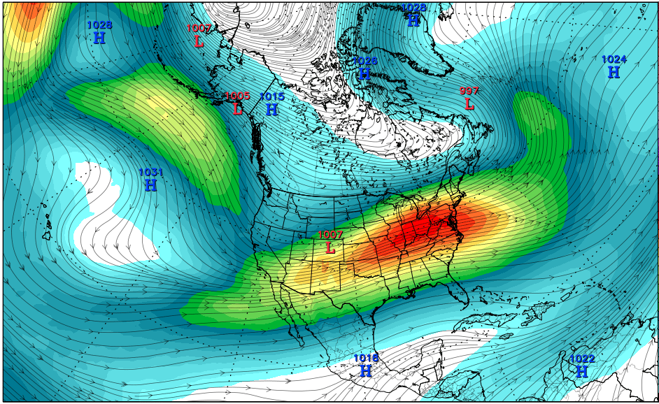
.SYNOPSIS...
A cold front will cross the region today, bringing isolated to
scattered valley rain showers and mountain snow showers. A
stronger disturbance will move through on Tuesday, which could
bring a period of snow to most of the region, with light to
moderate snow accumulations in some higher terrain areas. After
a tranquil weather day with seasonable temperatures Wednesday,
an impactful storm will approach from the southwest bringing
widespread wintry precipitation Wednesday night into Thursday.
&&
.SHORT TERM /TUESDAY THROUGH WEDNESDAY/...
Winter Weather Advisory issued for the southern Adirondacks and
southern Green Mountains from 10 am to 7 pm Tuesday...
A period of active winter weather is expected on Tuesday,
associated with a vigorous, progressive negatively tilted upper
level short wave moving through. Forcing is fairly
strong/compact just ahead of the vorticity maximum at the base
of the trough. Timing looks to be around late morning to early
afternoon across western areas and mid to late afternoon from
the Hudson Valley east. Will mention mainly categorical(80-90%)
PoPs due to high confidence in measurable QPF. With
strengthening S-SW flow in the 925-850 mb layer, highest QPF
will be across favored upslope areas of the southern Adirondacks
and southern Greens (elevations > 1500 ft). Snow accumulations
expected to exceed Advisory criteria in these areas, thus a
Winter Weather Advisory has been issued for 3-6" of snow.
&&
.LONG TERM /WEDNESDAY NIGHT THROUGH SUNDAY/...
An impactful winter storm is expected Wednesday night into
Friday. The synoptic setup features an upper-level high just to
the south of Florida and an upper-level low (or surface high
pressure) across Quebec. Upper-level energy will track between
these two features across our area. A west-to-east surface
frontal boundary will separate these two air masses which will
be near our area as a series of low pressure systems track along
the front. Sufficient moisture advection and isentropic lift
along and north of the boundary (on the cold air mass side) will
support widespread precipitation starting Wednesday night and
continuing into early Friday. All precipitation types are
expected with this event (snow, sleet, freezing rain and rain)
but accumulations of each remain uncertain. Northern areas have
the best chance at the highest snowfall accumulations as the air
will be colder there versus farther south as mixing will occur
at various stages of the event as a warm nose lifts northward
over these areas.
Where the boundary actually sets up will drive precipitation
types and amounts. This boundary will have a very sharp
temperature gradient and any shift north or south could lead to
drastically different surface precipitation types and
accumulations of snow, sleet and ice. As a result, expect
adjustments to the forecast leading up to the event.
Precipitation gradually ends later Thursday night and on Friday
as surface high pressure returns for Friday night. Windy
conditions are expected during the day Friday with some gusts in
excess of 30 mph. Friday night looks quite cold with many
locations dipping into the single digits above or below zero.
Gusty winds will make it feel much colder. Additional
precipitation chances next weekend as well which could be in the
form of rain and/or snow.
National Weather Service Albany NY
345 AM EST Mon Feb 20 2023
.SYNOPSIS...
A cold front will cross the region today, bringing isolated to
scattered valley rain showers and mountain snow showers. A
stronger disturbance will move through on Tuesday, which could
bring a period of snow to most of the region, with light to
moderate snow accumulations in some higher terrain areas. After
a tranquil weather day with seasonable temperatures Wednesday,
an impactful storm will approach from the southwest bringing
widespread wintry precipitation Wednesday night into Thursday.
&&
.SHORT TERM /TUESDAY THROUGH WEDNESDAY/...
Winter Weather Advisory issued for the southern Adirondacks and
southern Green Mountains from 10 am to 7 pm Tuesday...
A period of active winter weather is expected on Tuesday,
associated with a vigorous, progressive negatively tilted upper
level short wave moving through. Forcing is fairly
strong/compact just ahead of the vorticity maximum at the base
of the trough. Timing looks to be around late morning to early
afternoon across western areas and mid to late afternoon from
the Hudson Valley east. Will mention mainly categorical(80-90%)
PoPs due to high confidence in measurable QPF. With
strengthening S-SW flow in the 925-850 mb layer, highest QPF
will be across favored upslope areas of the southern Adirondacks
and southern Greens (elevations > 1500 ft). Snow accumulations
expected to exceed Advisory criteria in these areas, thus a
Winter Weather Advisory has been issued for 3-6" of snow.
&&
.LONG TERM /WEDNESDAY NIGHT THROUGH SUNDAY/...
An impactful winter storm is expected Wednesday night into
Friday. The synoptic setup features an upper-level high just to
the south of Florida and an upper-level low (or surface high
pressure) across Quebec. Upper-level energy will track between
these two features across our area. A west-to-east surface
frontal boundary will separate these two air masses which will
be near our area as a series of low pressure systems track along
the front. Sufficient moisture advection and isentropic lift
along and north of the boundary (on the cold air mass side) will
support widespread precipitation starting Wednesday night and
continuing into early Friday. All precipitation types are
expected with this event (snow, sleet, freezing rain and rain)
but accumulations of each remain uncertain. Northern areas have
the best chance at the highest snowfall accumulations as the air
will be colder there versus farther south as mixing will occur
at various stages of the event as a warm nose lifts northward
over these areas.
Where the boundary actually sets up will drive precipitation
types and amounts. This boundary will have a very sharp
temperature gradient and any shift north or south could lead to
drastically different surface precipitation types and
accumulations of snow, sleet and ice. As a result, expect
adjustments to the forecast leading up to the event.
Precipitation gradually ends later Thursday night and on Friday
as surface high pressure returns for Friday night. Windy
conditions are expected during the day Friday with some gusts in
excess of 30 mph. Friday night looks quite cold with many
locations dipping into the single digits above or below zero.
Gusty winds will make it feel much colder. Additional
precipitation chances next weekend as well which could be in the
form of rain and/or snow.