Winter Weather 22/23

Area Forecast Discussion
National Weather Service Burlington VT
720 AM EDT Fri Mar 17 2023

.LONG TERM /SUNDAY NIGHT THROUGH THURSDAY/...
As of 342 AM EDT Friday...The beginning of next week will see a large
ridge of high pressure that settles in giving us an period of quiet,
dry weather that looks to extend to at least the middle of next
week. Past midweek, things start to become a little more unsettled.
Models currently disagree on chances for any precipitation on
Wednesday or early Thursday, but all are currently leaning towards a
more organized system by the end of next week.
High temperatures
next week look to be in the 40s with overnight lows in the upper
teens to 20s.

I've seen rumblings of something for late next week that would top this most recent storm. Just saying..
 
I've seen rumblings of something for late next week that would top this most recent storm. Just saying..

Thanks for the heads up. I hadn't seen that, and it helps me plan.

Not seeing it in the GFS, but that doesn't really mean much.
 
Thanks for the heads up. I hadn't seen that, and it helps me plan.

Not seeing it in the GFS, but that doesn't really mean much.
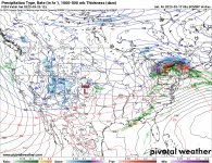
It's a wing and a prayer forecast, the euro had a low in the gulf spinning up the coast and feeding off of almost 80 degree waters, while cold air settled in over the northeast. There's a million reasons that won't happen, but it was fun to see. Right now I'm seeing this for next weekend. I'll be at Jay, so it could work out for me.
 

Attachments

  • prateptype_cat_ecmwf-imp.conus.png
    prateptype_cat_ecmwf-imp.conus.png
    275.5 KB · Views: 120
Last edited:
Happy Saint Patrick’s Day. ☘️
It’s a white one.
Gonna be cold this weekend.
Another EZ-peazy W.
White in which way. What's falling from the sky this morning is definitely not that here in Syracuse and not looking like it will be for the Daks either as the forecast has trended warmer for today's event
 
Yeah, I fear ski conditions are going to be for shite this weekend, unless fast and firm groomers is your thing.
 
White in which way. What's falling from the sky this morning is definitely not that here in Syracuse and not looking like it will be for the Daks either as the forecast has trended warmer for today's event
White as in all the snow that’s covering the ground.
It ain’t going away any time soon.
Get ready for corn season.
Supposed to snow couple inches this weekend.
Not bad for late March in the Cuse.
It ain’t over till it’s over.
It might not get to be over in the Sierras this year.
 
Yeah, I fear ski conditions are going to be for shite this weekend, unless fast and firm groomers is your thing.
If you go up (North) and up (above 3k) it won't be so bad. It's been snowing at Jay and Bolton this morning, they both think today will be a net-positive for snow.
 
Even the forecast for the Whiteface Mountain Observatory is for upper 30s and ncp. I’m less concerned with snowpack (net gain/loss) as this is a minor event. Surface conditions and off piste, however, after pushing 40 with ncp today followed by freezing temps…that’s not gonna be good.
 
Even the forecast for the Whiteface Mountain Observatory is for upper 30s and ncp. I’m less concerned with snowpack (net gain/loss) as this is a minor event. Surface conditions and off piste, however, after pushing 40 with ncp today followed by freezing temps…that’s not gonna be good.
Exactly this. We're not losing much snowpack wise. It looks like it's going to be enough temp and ncp wise though to wreck surface conditions until we get warm again and get into a corn cycle. Also looks like a temperature inversion is going on with a warm nose aloft so temperature is steady to increasing as you go up.
 
Back
Top