- Joined
- Jul 15, 2020
My plan was to take today off and ski Big Mac tomorrow. So far however it looks like just a few inches of lake effect have fallen in Old Forge. So I went a bit farther into the Siamese today, trying to find a place we used to ski to back in the day.
When I first started skiing the Garnet Hills, in the late 80s, I used to explore the woods with a skier named Rand. He was a waiter at the Lodge, and we got to know him that way. (He also built our camp.)
He loved to look at maps, mostly the 13th Lake USGS quad and pick out interesting spots, and find them on skis with map and compass. Rand was amazing with map and compass. When we'd bushwhack, he'd look at the map, choosing his route, and I would follow with compass, only correcting him when he was off our line after multiple heading checks.
This map is a section of one of my favorites. It's so old and tattered that today, I took a picture of it, in case I wanted to look at it. North is roughly towards the top of the map.

One of the first random spots Rand picked out he named 757T. It's the spot labeled 2473 (feet) at the bottom of this map.
From the ski shop we went up to the Hooper Mine...

Hooper Mine Trail
... and then skied towards William Blake Pond. We headed around the hill above the pond on the map. It's a bit of a challenge to find the right line. If you go too high on the hill you get into lots of small pines that are difficult to navigate. If you go too low you are dealing with blowdown and a series of draws that make the skiing tough.
The first time we attempted to find 757T, we eventually made it up to the ridgeline above the Halfway Brook Trail which connected Garnet Hill and Highwinds, the lodge owned by Barton's. Back when Highwinds was open, Halfway Brook was a busy route, serving guided skis for GH Lodge guests.
The Halfway Brook Trail is below the ridgeline, and when we made it to that spot, we heard a group of skiers 200 feet below us. I always thought Rand was part wolf, and when he heard the skiers below, he started howling. That night at dinner in the lodge we heard several guests talking about the wolf they heard out on the trail. We got a huge kick out of that.

Finding the best line on the way up
When we got to 757T there was a nice view of Gore, which is since grown in. Our goal was that knife-edge (lol) ridgeline to the north of 757T. From there, theoretically we thought you should be able see the remains of the old Garnet Mountain ski area, which is just north of the hairpin turn on Barton's Road, at the righthand edge of the map above. If you look closely you can see the dotted lines that represent the trails on the far side of Barton's Road.

Photo of Garnet Mountain courtesy of NELPSAP.org
The farthest we made it was to the cliffs just to the east of the vertical "2300" on the map, far above Trapper Trail. We did see the remains of the ski area back then. It looked like the image above, but grown in. I think that shot was taken from the same spot.
The other thing notable about the knife-edge area was the prevalence of cat prints. They were everywhere. We came to call that spot "Cat Country."

757T
757T is kind of a non-descript spot now, with views obscured.
Another thing notable about 757T... I took Zelda there when she told me she wanted to try winter camping. I figured we were pretty close to the trailhead in case we had any trouble. It was 30 below that night, and if you can believe it she had a great time. We definitely had the gear, we took three sleeping bags, 2 rated to 20F and one rated to -35, that she used, and stayed warm. The morning was glorious as our yellow North Face tent was filled with sun from the sunrise.
At about 2:30, as I was heading north from 757T, my phone rang. We had ordered living room furniture back in September and we had the proverbial delivery "window" from 5-7pm, but this call was telling me that truck was arriving any minute. I begged the guy to wait for me, not knowing how long it would take to reschedule. (We've had no couch or dining room table since we moved in, in September.) I beat a hasty retreat and got home in less than an hour. It's much faster getting down, because of the vert, and with the route marked by my tracks.
While the route is still tracked out, I'll likely go back and see if I can get to the knife edge. It's not that narrow, but when you are skiing you can definitely see down both sides, which very cool.
Ski Day 48
When I first started skiing the Garnet Hills, in the late 80s, I used to explore the woods with a skier named Rand. He was a waiter at the Lodge, and we got to know him that way. (He also built our camp.)
He loved to look at maps, mostly the 13th Lake USGS quad and pick out interesting spots, and find them on skis with map and compass. Rand was amazing with map and compass. When we'd bushwhack, he'd look at the map, choosing his route, and I would follow with compass, only correcting him when he was off our line after multiple heading checks.
This map is a section of one of my favorites. It's so old and tattered that today, I took a picture of it, in case I wanted to look at it. North is roughly towards the top of the map.
One of the first random spots Rand picked out he named 757T. It's the spot labeled 2473 (feet) at the bottom of this map.
From the ski shop we went up to the Hooper Mine...
Hooper Mine Trail
... and then skied towards William Blake Pond. We headed around the hill above the pond on the map. It's a bit of a challenge to find the right line. If you go too high on the hill you get into lots of small pines that are difficult to navigate. If you go too low you are dealing with blowdown and a series of draws that make the skiing tough.
The first time we attempted to find 757T, we eventually made it up to the ridgeline above the Halfway Brook Trail which connected Garnet Hill and Highwinds, the lodge owned by Barton's. Back when Highwinds was open, Halfway Brook was a busy route, serving guided skis for GH Lodge guests.
The Halfway Brook Trail is below the ridgeline, and when we made it to that spot, we heard a group of skiers 200 feet below us. I always thought Rand was part wolf, and when he heard the skiers below, he started howling. That night at dinner in the lodge we heard several guests talking about the wolf they heard out on the trail. We got a huge kick out of that.
Finding the best line on the way up
When we got to 757T there was a nice view of Gore, which is since grown in. Our goal was that knife-edge (lol) ridgeline to the north of 757T. From there, theoretically we thought you should be able see the remains of the old Garnet Mountain ski area, which is just north of the hairpin turn on Barton's Road, at the righthand edge of the map above. If you look closely you can see the dotted lines that represent the trails on the far side of Barton's Road.
Photo of Garnet Mountain courtesy of NELPSAP.org
The farthest we made it was to the cliffs just to the east of the vertical "2300" on the map, far above Trapper Trail. We did see the remains of the ski area back then. It looked like the image above, but grown in. I think that shot was taken from the same spot.
The other thing notable about the knife-edge area was the prevalence of cat prints. They were everywhere. We came to call that spot "Cat Country."
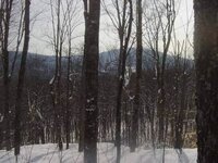
757T
757T is kind of a non-descript spot now, with views obscured.
Another thing notable about 757T... I took Zelda there when she told me she wanted to try winter camping. I figured we were pretty close to the trailhead in case we had any trouble. It was 30 below that night, and if you can believe it she had a great time. We definitely had the gear, we took three sleeping bags, 2 rated to 20F and one rated to -35, that she used, and stayed warm. The morning was glorious as our yellow North Face tent was filled with sun from the sunrise.
At about 2:30, as I was heading north from 757T, my phone rang. We had ordered living room furniture back in September and we had the proverbial delivery "window" from 5-7pm, but this call was telling me that truck was arriving any minute. I begged the guy to wait for me, not knowing how long it would take to reschedule. (We've had no couch or dining room table since we moved in, in September.) I beat a hasty retreat and got home in less than an hour. It's much faster getting down, because of the vert, and with the route marked by my tracks.
While the route is still tracked out, I'll likely go back and see if I can get to the knife edge. It's not that narrow, but when you are skiing you can definitely see down both sides, which very cool.
Ski Day 48