
Ripitz
Well-known member
- Joined
- Dec 23, 2020
Powerman and I have been working our way through the Catskill High Peaks together and it’s been quite a journey. Recently we had a window of opportunity but unfortunately he became sick at the last minute, so I set off on my own.
I took off from Hopewell Junction at 7:30pm on the Dutchess County Rail Trail with my gravel ebike known as the Car Crusher. The plan was to ride to Hunter and spend the night at a friend’s slopeside condo. From there I would hike the peaks that I knew Powerman had already done but I hadn’t, Hunter and Southwest Hunter, AKA Leavitt Peak. If I had time, maybe I could sneak in Rusk.
The Walkway Over the Hudson closed at 8pm and I missed it by 2 minutes so I detoured over the Mid-Hudson bridge.

I followed the Empire State Trail up through New Paltz and Cottekill then hit some country roads.


I got up into Marbletown and had to hide out under a pavilion at the town park while some massive thunderstorms pounded the area. I spent the time struggling with a slow water filter which was only providing a frustratingly slow drip.
Once the storms had passed I set out again and a full moon revealed itself once I got up near the Ashokan Reservoir. It was really something else to be up there all alone in the middle of the night.

After getting some rest at the condo and charging the bike my plan was to hike Hunter and SWH on a loop using the Spruceton Trail and the Devil’s Path. Instead of using the Becker Hollow or DP trailheads or riding all of the way around to the Spruceton Valley, I wanted to come in through Diamond Notch. The route through the Notch is longer for hiking but much less steep. I hadn’t been through there before and was really looking forward to checking out this ancient highway.

But by the time I got up to Lanesville it was already 4:30 in the morning and getting light out. I decided I would bail on continuing to the condo and just start hiking.

By 5:30am I had ditched the Car Crusher and was on the trail.

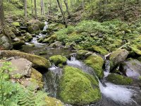
What a beautiful place and a peaceful morning.

Diamond Notch connects two watersheds and has been most likely used for thousands of years.

Looking back, Slide, Cornell and Wittenberg were barely visible in the distance.

A pointer tree marked the height of land at the top of the pass.

I stopped to check out the Diamond Notch Lean-to.

Then it was on to Diamond Notch Falls.


I was making decent time but I didn’t want to linger. My plan was a loop from here so I would be visiting the falls again. I hit the Spruceton Trail and decided to go for the bushwhack to Rusk and East Rusk since I was in the area and feeling good. Might as well check another High Peak off the list while here and explain it to Powerman later.


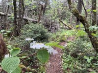
The bushwhack peaks aren’t really bushwhacks anymore. A one-two punch of COVID and social media has turned them into well worn herd paths.

But it still is some beautiful country.

Our native hydrangea.

Just as I hit the summit and found the canister, another thunderstorm passed through which had me questioning the integrity of my discount drugstore umbrella.

It had been two days since the last people passed through.

I took off from Hopewell Junction at 7:30pm on the Dutchess County Rail Trail with my gravel ebike known as the Car Crusher. The plan was to ride to Hunter and spend the night at a friend’s slopeside condo. From there I would hike the peaks that I knew Powerman had already done but I hadn’t, Hunter and Southwest Hunter, AKA Leavitt Peak. If I had time, maybe I could sneak in Rusk.
The Walkway Over the Hudson closed at 8pm and I missed it by 2 minutes so I detoured over the Mid-Hudson bridge.
I followed the Empire State Trail up through New Paltz and Cottekill then hit some country roads.
I got up into Marbletown and had to hide out under a pavilion at the town park while some massive thunderstorms pounded the area. I spent the time struggling with a slow water filter which was only providing a frustratingly slow drip.
Once the storms had passed I set out again and a full moon revealed itself once I got up near the Ashokan Reservoir. It was really something else to be up there all alone in the middle of the night.
After getting some rest at the condo and charging the bike my plan was to hike Hunter and SWH on a loop using the Spruceton Trail and the Devil’s Path. Instead of using the Becker Hollow or DP trailheads or riding all of the way around to the Spruceton Valley, I wanted to come in through Diamond Notch. The route through the Notch is longer for hiking but much less steep. I hadn’t been through there before and was really looking forward to checking out this ancient highway.
But by the time I got up to Lanesville it was already 4:30 in the morning and getting light out. I decided I would bail on continuing to the condo and just start hiking.
By 5:30am I had ditched the Car Crusher and was on the trail.
What a beautiful place and a peaceful morning.
Diamond Notch connects two watersheds and has been most likely used for thousands of years.
Looking back, Slide, Cornell and Wittenberg were barely visible in the distance.
A pointer tree marked the height of land at the top of the pass.
I stopped to check out the Diamond Notch Lean-to.
Then it was on to Diamond Notch Falls.
I was making decent time but I didn’t want to linger. My plan was a loop from here so I would be visiting the falls again. I hit the Spruceton Trail and decided to go for the bushwhack to Rusk and East Rusk since I was in the area and feeling good. Might as well check another High Peak off the list while here and explain it to Powerman later.
The bushwhack peaks aren’t really bushwhacks anymore. A one-two punch of COVID and social media has turned them into well worn herd paths.
But it still is some beautiful country.
Our native hydrangea.
Just as I hit the summit and found the canister, another thunderstorm passed through which had me questioning the integrity of my discount drugstore umbrella.
It had been two days since the last people passed through.
Attachments
Last edited:
")


