APphysics
Member
- Joined
- Feb 5, 2024
Part 1
July 2nd, 2024. Around 5:10am, red taillights belonging to Crawler’s van come into view. Giving the truck more gas, I close the gap between the two vehicles. On the tight two-lane road, I rip past the van and gun it up the mile long hill. We are headed for the DEC parking lot that crowns the Devils Kitchen—the finish line for the Herb. Once there, we transfer Crawler’s bike to the truck and continue on to Prattsville with a short detour to cache food. What lies ahead is a seventy mile bike ride with high frequency gain that traverses the scenic Catskill Mountains.

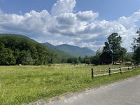
We ditch the truck at the Prattsville Town Park and begin our tour. The first ascent is only a mile or so into the route—Cozy Hollow Road. The climb lasts five miles and includes two main hills. A short reprieve between the two allow entire views of the countryside. Across the valley, Bearpen’s ridge breaks the horizon. In the foreground, Crawler takes photos of his favorite roadside attraction: the cow. The second climb is up the shoulder of Huntersfield Mountain. It is a stout double track known as Jim Cleveland Road. The crux of the climb is the last quarter at grades over 15%—steep enough to rear a bike with careless pedal strokes. Once on top, my watch buzzes, marking the first five mile lap—gaining about 1,800ft. We prepare for the cruiser ride back to the Schoharie.


Jim Cleveland Road
The descent will take us to the village of Prattsville. The coast down provides constant views of obstacles that lie ahead. Up to and including this moment, the ride feels like any other ride—reality of length and hardship has yet to surface. In the grand scheme of things, the Herb has just begun and Huntersfield was only a warmup. The closer we get to the valley floor, the more Bearpen Mountain disappears beyond trees. All the previous elevation we achieved is now gone. The next climb is the longest and highest. This ascent boasts 2,500ft of gain over seven miles, which isn’t record smashing, but still a grind. The reward at the summit is the opportunity to say you pedaled one of the Catskill 3500s. The pedal up is taxing and starts by climbing out of the Schoharie Creek valley on paved roads. We come upon one demoralizing false summit and it drops us back down into a quaint valley. Once up the other side, the horizon reveals pastoral farmland backdropped by Bearpen. Joy floods my nervous system then quickly fades. There is no rewarding downhill to follow, only a slight right onto a dusty double track that keeps going up. This is Ski Run Road.

It’s my third time biking up Ski Run Road. The two previous times had a few hike-a-bike sections. Crawler and I push on, pointing out where we stopped for water last year—all dried up. I think enviously of winter and how smooth this road is when groomed with snow. We slowly crank our way up the eastern side of Roundtop. Biking sections that were previously walked, I realize my legs are stronger than before. Soon enough the crux section is over, I am on the shoulder of Roundtop, elated with accomplishment. This is by far my best performance of the climb yet. I sit down, munch on banana chips and dried mangos, waiting for Crawler to round the corner. He is not far behind.

Even though we are on the ridge, there is still climbing ahead. The ridge ride is an easy double track that traverses all the way to Bearpen. Surprisingly, the latter part is often wet with deep puddles. We arrive at the headwall of Bearpen—the last steep push right before the summit—another section I’ve aways walked the bike. Still feeling strong, I pedal through, fighting my way up loose Catskill chonk to the top. We take a break and look out over the valley. Huntersfield Mountain is off in the distance, marking the edge of Greene County. It looks like a dinky hill from our current roost. After the uphill slog, we are finally rewarded a dirt descent. Coming off Bearpen Mountain is an old fashion hoot. About two hours of hard labor will be erased in 12 minutes. We turn off the double track and head down the hikers’ trail. This section brings out the reason why I like heinous steeps: unadulterated technical downhill—mountain biking at its core. This trail is historically made for hiking which makes for a steep and rewarding learning curve on a bike. Bearpen’s trail is tight, muddy and fast. Quick attention to smooth lines pays off when riding a hard-tail bike. Once on the lower snowmobile trail, we bomb past the hunter’s cabin and beeline it down County 3 Road. We stop at our third watering hole, fill our bottles, eat some grub and continue to our next climb.


Turning left onto Bouton Road and then a quick right onto Turk Hollow takes us 950ft up onto the saddle between South Vly and Sleeping Lion mountains. Then this dirt lane becomes Condon Hollow Road. The climb is a tougher one due to the poor condition of the road. For us, while conserving energy, most of it is hike-a-bike. This is the first time in the journey that stinging nettles bear their fierce leaves. On the way up, they are easily avoided and trodden upon, however, the descent is the opposite. If you thought hiking through nettles was bad, wait until they are lacerating your shins at 17 miles per hour. In July, they are at perfect height for maximum damage and there is no hiding. Our pace is slowed by multiple blowdowns, forcing us to dismount and fight our way through their tangled branches. With legs on fire from the siege of nettles, we execute the final turn within the trail. The last 3/10ths of a mile is a brutal flogging of thick nettles and maneuvering over baby-head sized rocks. We hit the stone road with yells of celebration and pain. The neglected DEC lot briefly becomes an infirmary as we pour water over our red legs and hold a safety meeting.


Popping out onto South Beech Road is a pleasure after what was just endured. There’s a picturesque view of the Spruceton Valley and an excitingly fast ride down to get there. Spruceton Road is a long stretch that continuously gains elevation (1,450ft) over eight miles to Diamond Notch. We forego tempting libations at West Kill Brewery and decided to get to our provisions on Route 214 as quickly as possible.

Diamond Notch, officially categorized as a primitive bike corridor, will be tackled next. Unlike the top and bottom sections, the middle of this climb is hard to ride due to large rocks. Around the lean-to, we hop onto our saddles and pedal to the crest. We glove up for one of the more exciting downhills of the route. The trail cuts into the steep notch on its eastern side. The path is narrow and exposed with steep scree above and below. While in the notch, you feel as though you are somewhere barren. Speed is gained as the trail widens. It is an entertaining descent with drops and loose rocks. A stream crossing comes up fast and we dismount to ford. The section after is slow and technical. Larger boulders need to be navigated with agility and care. Reaching Diamond Notch Road means that we are halfway through our demented scheme. The ascent up Route 214 into Stony Clove Notch is my mental crux. It is a tedious slog up boring blacktop. I swear I pass Notch Inn Road twice every time this section is traveled. After what seems to be hours, we reach the notch and coast down to our cache full of goodies.

The creek crossing

July 2nd, 2024. Around 5:10am, red taillights belonging to Crawler’s van come into view. Giving the truck more gas, I close the gap between the two vehicles. On the tight two-lane road, I rip past the van and gun it up the mile long hill. We are headed for the DEC parking lot that crowns the Devils Kitchen—the finish line for the Herb. Once there, we transfer Crawler’s bike to the truck and continue on to Prattsville with a short detour to cache food. What lies ahead is a seventy mile bike ride with high frequency gain that traverses the scenic Catskill Mountains.
We ditch the truck at the Prattsville Town Park and begin our tour. The first ascent is only a mile or so into the route—Cozy Hollow Road. The climb lasts five miles and includes two main hills. A short reprieve between the two allow entire views of the countryside. Across the valley, Bearpen’s ridge breaks the horizon. In the foreground, Crawler takes photos of his favorite roadside attraction: the cow. The second climb is up the shoulder of Huntersfield Mountain. It is a stout double track known as Jim Cleveland Road. The crux of the climb is the last quarter at grades over 15%—steep enough to rear a bike with careless pedal strokes. Once on top, my watch buzzes, marking the first five mile lap—gaining about 1,800ft. We prepare for the cruiser ride back to the Schoharie.
Jim Cleveland Road
The descent will take us to the village of Prattsville. The coast down provides constant views of obstacles that lie ahead. Up to and including this moment, the ride feels like any other ride—reality of length and hardship has yet to surface. In the grand scheme of things, the Herb has just begun and Huntersfield was only a warmup. The closer we get to the valley floor, the more Bearpen Mountain disappears beyond trees. All the previous elevation we achieved is now gone. The next climb is the longest and highest. This ascent boasts 2,500ft of gain over seven miles, which isn’t record smashing, but still a grind. The reward at the summit is the opportunity to say you pedaled one of the Catskill 3500s. The pedal up is taxing and starts by climbing out of the Schoharie Creek valley on paved roads. We come upon one demoralizing false summit and it drops us back down into a quaint valley. Once up the other side, the horizon reveals pastoral farmland backdropped by Bearpen. Joy floods my nervous system then quickly fades. There is no rewarding downhill to follow, only a slight right onto a dusty double track that keeps going up. This is Ski Run Road.
It’s my third time biking up Ski Run Road. The two previous times had a few hike-a-bike sections. Crawler and I push on, pointing out where we stopped for water last year—all dried up. I think enviously of winter and how smooth this road is when groomed with snow. We slowly crank our way up the eastern side of Roundtop. Biking sections that were previously walked, I realize my legs are stronger than before. Soon enough the crux section is over, I am on the shoulder of Roundtop, elated with accomplishment. This is by far my best performance of the climb yet. I sit down, munch on banana chips and dried mangos, waiting for Crawler to round the corner. He is not far behind.
Even though we are on the ridge, there is still climbing ahead. The ridge ride is an easy double track that traverses all the way to Bearpen. Surprisingly, the latter part is often wet with deep puddles. We arrive at the headwall of Bearpen—the last steep push right before the summit—another section I’ve aways walked the bike. Still feeling strong, I pedal through, fighting my way up loose Catskill chonk to the top. We take a break and look out over the valley. Huntersfield Mountain is off in the distance, marking the edge of Greene County. It looks like a dinky hill from our current roost. After the uphill slog, we are finally rewarded a dirt descent. Coming off Bearpen Mountain is an old fashion hoot. About two hours of hard labor will be erased in 12 minutes. We turn off the double track and head down the hikers’ trail. This section brings out the reason why I like heinous steeps: unadulterated technical downhill—mountain biking at its core. This trail is historically made for hiking which makes for a steep and rewarding learning curve on a bike. Bearpen’s trail is tight, muddy and fast. Quick attention to smooth lines pays off when riding a hard-tail bike. Once on the lower snowmobile trail, we bomb past the hunter’s cabin and beeline it down County 3 Road. We stop at our third watering hole, fill our bottles, eat some grub and continue to our next climb.
Turning left onto Bouton Road and then a quick right onto Turk Hollow takes us 950ft up onto the saddle between South Vly and Sleeping Lion mountains. Then this dirt lane becomes Condon Hollow Road. The climb is a tougher one due to the poor condition of the road. For us, while conserving energy, most of it is hike-a-bike. This is the first time in the journey that stinging nettles bear their fierce leaves. On the way up, they are easily avoided and trodden upon, however, the descent is the opposite. If you thought hiking through nettles was bad, wait until they are lacerating your shins at 17 miles per hour. In July, they are at perfect height for maximum damage and there is no hiding. Our pace is slowed by multiple blowdowns, forcing us to dismount and fight our way through their tangled branches. With legs on fire from the siege of nettles, we execute the final turn within the trail. The last 3/10ths of a mile is a brutal flogging of thick nettles and maneuvering over baby-head sized rocks. We hit the stone road with yells of celebration and pain. The neglected DEC lot briefly becomes an infirmary as we pour water over our red legs and hold a safety meeting.
Popping out onto South Beech Road is a pleasure after what was just endured. There’s a picturesque view of the Spruceton Valley and an excitingly fast ride down to get there. Spruceton Road is a long stretch that continuously gains elevation (1,450ft) over eight miles to Diamond Notch. We forego tempting libations at West Kill Brewery and decided to get to our provisions on Route 214 as quickly as possible.
Diamond Notch, officially categorized as a primitive bike corridor, will be tackled next. Unlike the top and bottom sections, the middle of this climb is hard to ride due to large rocks. Around the lean-to, we hop onto our saddles and pedal to the crest. We glove up for one of the more exciting downhills of the route. The trail cuts into the steep notch on its eastern side. The path is narrow and exposed with steep scree above and below. While in the notch, you feel as though you are somewhere barren. Speed is gained as the trail widens. It is an entertaining descent with drops and loose rocks. A stream crossing comes up fast and we dismount to ford. The section after is slow and technical. Larger boulders need to be navigated with agility and care. Reaching Diamond Notch Road means that we are halfway through our demented scheme. The ascent up Route 214 into Stony Clove Notch is my mental crux. It is a tedious slog up boring blacktop. I swear I pass Notch Inn Road twice every time this section is traveled. After what seems to be hours, we reach the notch and coast down to our cache full of goodies.
The creek crossing

