
I had a chance to see much of the new terrain at Gore with Mike Pratt on Saturday. Progress looked good. We started up Wild Air to see the new “low-angle learning glade” Chatterbox.
We checked out the center line that’s been cut to the skier’s right on Wild Air. This “new” tree shot is actually the rebirth of something that had been skied in the recent and distant past. Mike’s goal for the run is to keep it close enough to the trail to allow the glade to capture snowmaking blow-by from the trail.
Up and over to Twister. And down to Hedges. Right now, Hedges is a work road. It would require dynamite and earth-moving equipment to turn the road into a connector between the top of the Burnt Ridge Quad and Twister. It’s in the long term plan, but not in the immediate future.
At the top of Burnt Ridge we climbed over a pile of boulders that will eventually be the entrance to Barkeater. The recently cut Barkeater center line was reasonably well marked, so Mike agreed to let me hike through and reconnect with him down on Pipeline. We settled on a compass heading for an extra margin of safety, and I set off.
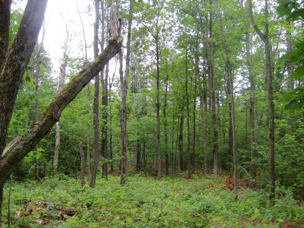
It’s beautiful. Almost all of the upper section is lined with ferns and soft peaty soil. It seem to me that the top half would be skiable with small amounts of snow. I find it hard to judge pitch in the summer. But it seems to me that much of Barkeater is a steeper than Twister Glades.
As you work your way down, it gets much steeper and you start seeing lots of options on skier’s left. It looks like there is potential for many lines on the lower half.
In Barkeater, if you head down anywhere, you’ll eventually cross the power lines and come out on Pipeline. The total vertical on Barkeater is 1060 feet. The official exit is about 300 feet above the new Roaring Brook bridge.
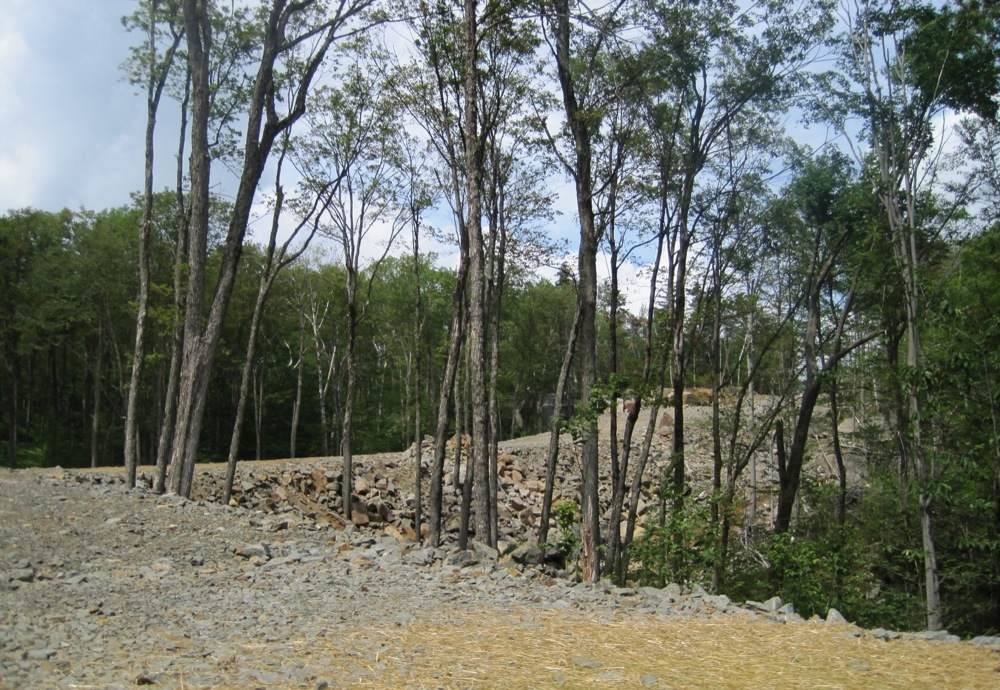
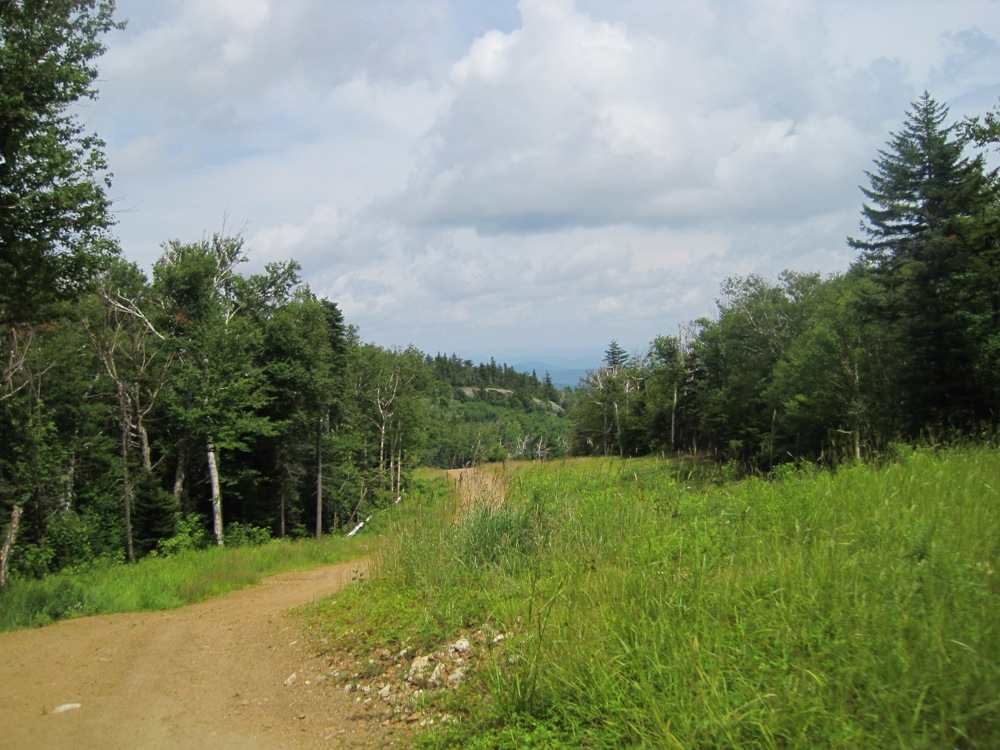
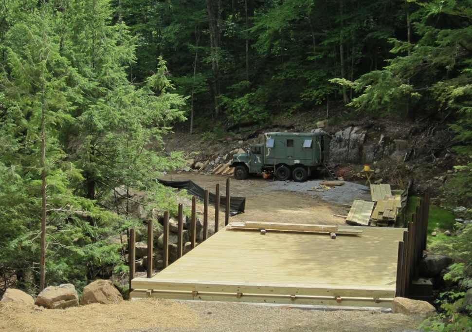
Gore did literally TONS of work to create a skiable route from Little Gore to the base of Burnt Ridge. At one point, we were standing on 30 feet of bouldered fill.
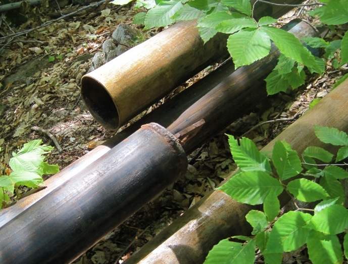
Snowmaking pipe is welded and in place about halfway up Oak Ridge. The raw pipe comes in 100-foot lengths and is either used as is, or is welded in 300-foot pieces and then dragged uphill by a skidder. It’s laid in place and connector angles are inserted to accommodate turns in the trail.
Moxham is the only trail that is not retaining its original Ski Bowl name. It was called The Ridge Trail. Gore felt that with Topridge, Burnt Ridge and Oak Ridge in the mix, the addition of The Ridge Trail might lead to confusion on the radio.
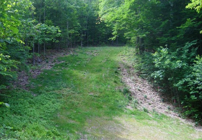
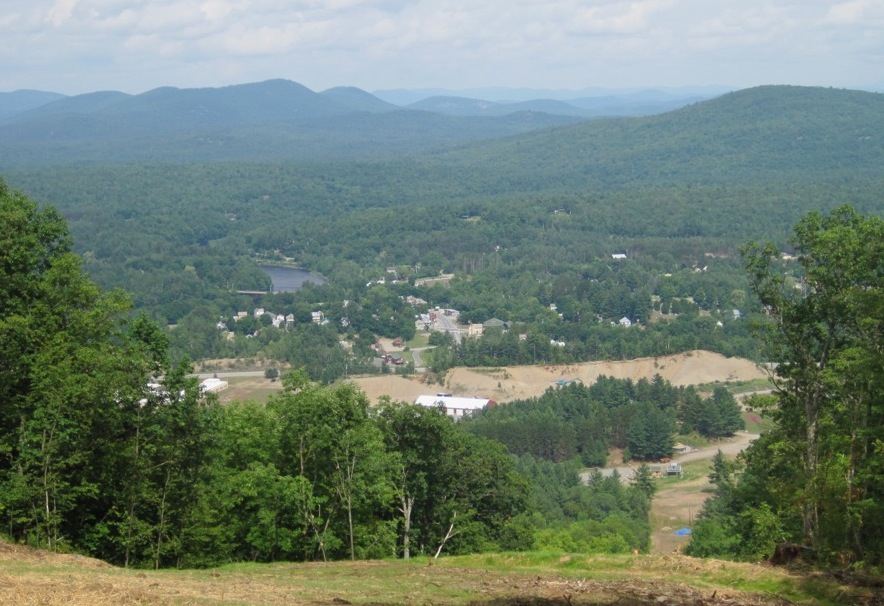
We made our way over to 46er on Peaceful Valley. Mike explained that 46er was named because the original T-bar was built in 1946. The fact that it’s also a reference to the tallest peaks in NY State was a happy coincidence.
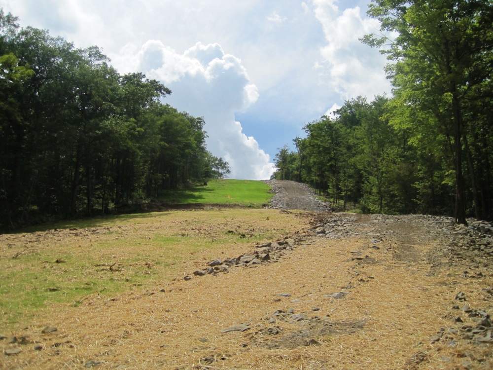
The trail is covered in soil, grass and hay and almost complete.
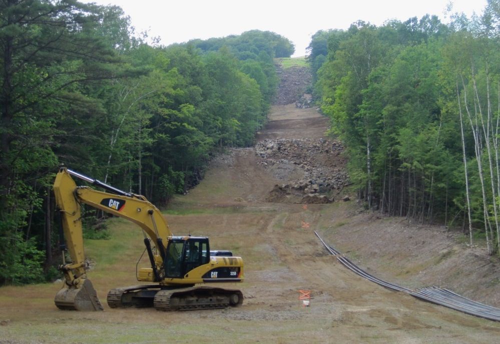
But plenty of work still lies ahead. Tower foundations have to be poured in advance of the day when the towers will be installed. The steepest sections will be done with a helicopter.
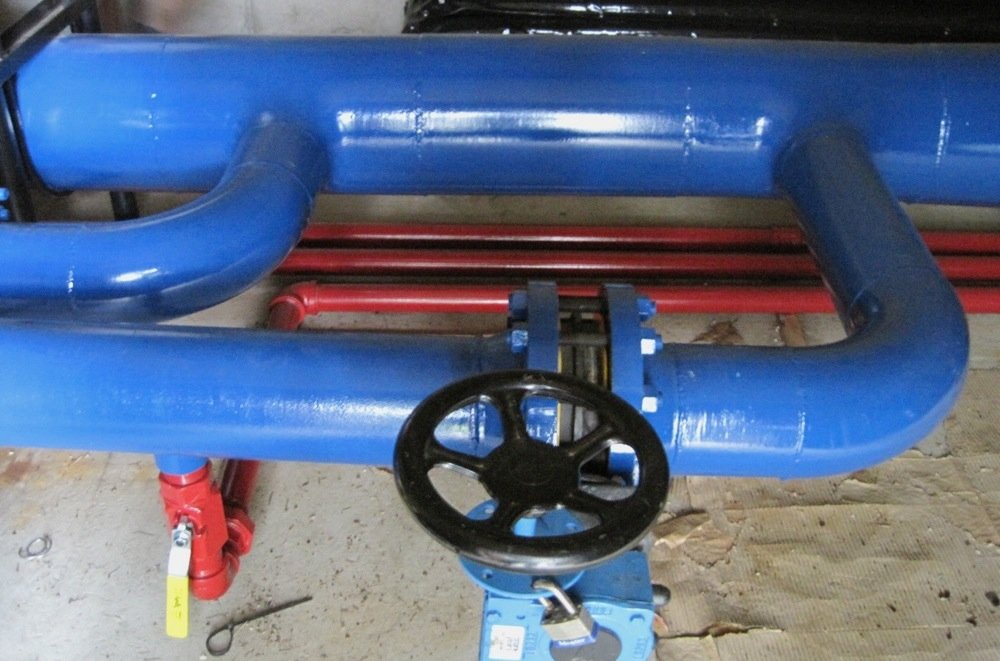
The Hudson River pipeline has an in-line valve housed in the basement of the lift operator and patrol building at the top of the Village Chair. It’s 12 inches in diameter and can easily handle the 5000 gpm that Gore is permitted to pump from the Hudson. From this location, water is directed around the Ski Bowl directly from the River.
Friday night we spent some time walking through town. It’s great to be able to see a small part of the mountain in the spaces between buildings on Main Street. What hadn’t occurred to me before I was up on 46er — you can also see town from the mountain. It would be great if that view could entice more skiers into North Creek to see everything there is to do in town.
Thanks for keeping us up to date on what is going on. I was up this weekend too and that 46er trail looks awesome. Do you feel that getting to the ski bowl will be the giant skate that it was last year or has that been addressed?
Nice tale Harv. Good job. You guys covered a lot of ground, 4 wheeling around in a truck? That would be fun. Pray for snow.
The photo you titled the road to lil Gore, is that lower end of Eagle’s nest? or the upper end above the Troll bridge? They sure moved a lot of rock fill in that photo, all graded nice, top is smooth. Great job! Rock can make a nice heavy and stable foundation. Wonder if Uncle Mikie would let me take my quads up there for a tour? 😉 Pretty Please!
Skiing from Burnt Ridge to the Ski Bowl and vice versa will require some traversing (this IS still Gore!)
Nice pictures Harv. Progess is coming along nicely isn't it. The Moxham trail name debate is not over yet, although Emily may think it is.
Anyways… think snow!
Good update- smart move catching a ride with Mike…way too muggy this past weekend! I’ve hiked up there enough to know that there will be some skating required. I wonder if Gail ever considered offering a skating clinic for alpine skiers?!
Goreskimom … you are welcome. I agree 46er looks sweet. Because I went through the trees on Barkeater, I didn’t see all of Pipeline. And Snowballs can tell you that my ability to judge pitch while walking in the summer is lame. But from what I saw, I don’t think more blasting is practical.
AdkSkier is right – there will be some skating involved unless you buy a ticket and drive around. I feel the same way about Little Gore that I do about Burnt Ridge: there’s some great terrain there, and I’m happy we are getting it.
Snowballs … The photo should have been named the Road from Little Gore. It was taken on Peaceful Valley above the bridge.
Nice update! I’m looking forward to getting into those woods again now that they are trimmed. Imagine skiing from the top to town inbounds, by only skiing woods, crossing the occasional trail… I Have A Dream!
Looks like we will have a significant amount of new gladed terrain added to the trail map for next year. These additions must put Gore near the top of the list for East Coast gladed terrain.
Harv, how much vert in the new Chatterbox Glade? Where does it exit? Did Mike mention any possibility of an entrance to Chatterbox directly from Sunway in order to alleviate potential interference with the terrain park?
I didn’t ski Pipeline last year, but from Goreskimom’s and others’ comments it sounds like there will be some flat sections on that. For anyone who did ski Pipeline last year, how does it compare to say Cedars or Cloud below Windy Hill in terms of flatness and traversing required, and where do the flat spots occur? Would the Barkeater Glades bypass the flat sections of Pipeline? Does skiing from the top of the Ski Bowl chair to BRQ entail any traversing?
Let’s talk snowmaking. Since the new trails at the Ski Bowl will not put additional demand directly on the pumping station at the base of the North Quad, doesn’t that mean Gore should have plenty of capacity to bury the new trails this winter, in particular 46er (assuming pipe installation is completed)? That could mean that this new terrain may become skiable relatively early in the season.
We’re almost at the half-way point in the non-skiing months. Here’s hoping for a long, cold, snowy winter!
The Pipeline flats, IMO, even with a good head of steam, seemed a little longer than the Cedars flats or the Cloud flats. The Pipeline’s flats occur towards it’s beginning and in fact have some uphill sections. After that it’s kinda fun. Narrow and windy with a few more short and steep-er sections.
It looks to me from Harv’s photos that Eagle’s Nest, after the Troll bridge, will be some what up-ish.
I’ve gotten over the Flat blues. I now look at them as a chance to get some exercise. However they do sometimes keep me off the those trails. Echo is a good example. First part is great but the bottom across Cedars is a huge bore.
Oh, well. I’m not sure there’s much anyone could do to remedy the flats.
Chatterbox comes out on 3B. That’s some decent vert. If it’s 700 feet, it could put the glade 4th behind Cirque, Barkeater and Twister. I was curious, so I asked Mike for an official number.
With regard to snowmaking, I wonder if they’d actually open the bowl without enough snow to make a connection from the base area. That would require duplicate ticket services. Might be tough with the budget situation.
I’m with GW. I’m over the whole flats thing. As an XC skier you learn … the more work it is to get there, the more untracked snow you find when you arrive.
That’s what I call The Gore Mountain Shuffle.
Harv, thanks again. Photos were awesome. I love looking (and walking) at the fauna of a mountain in summer.
On the pipeline questions, Harv mentions some steep and narrow spots. When I hiked and biked this last fall..I thought, "when they open this, some folks will be fooled at the flats and then be surprised by some of the steeper parts. I can see kids and new skiers being frozen stiff in some areas. The trail should not be an adventure “for less skilled skiers” Also, with limited snow making, I can see bare spots on those steeper areas making them even more tretcherous for less skilled. Fun for me though–I get off on 1'0 wide snow bands.
🙂
I:) skiing .. thanks. I am always amazed at how different the mountain looks in the summer. I’ve noticed that things seem much steeper when I am walking them. The section of Pipeline right after the exit from Barkeater, and above the new bridge, while not that steep on an absolute scale, was pretty narrow – not much more than a one lane road – and could be considered a little hairy. FYI – I posted all the above pics in if you’d like to see them a little bigger.
Flora—not fauna(oops)…don’t like walking on fauna, unless its black widows or brown reculses. To me, skiing steeps always seems less steep than walking/hiking. Twice on Pipeline with breaks on FULL and wheels stopped,my bike was skidding down. I think you can call that steep, but these would definitely be blue squares. They were kind of like the little head wall at the base of 3b before the intersection but longer and like Harv said narrow, about 20 feet. 25 at the most.
I’m over “the flats thing” too with the exception of poling from ADK Express to Burnt Ridge Quad, especially when Twister is closed for racing! But I just keep poling and repeating to myself quietly, “you are earning your apre, you are earning your apre.”
Re: The question about the pipeline as compared to flat spot on Cloud, NO comparison. My son and I have done the Pipeline several times in the last few years with Minimal poling. I think the narrow trail and tree coverage (plus being on the dark side) keeps the sun from ever getting a really clear shot. If you have a little speed built up at the bottom of North Quad as you enter Pipeline it is actually fun!
CORRECTION: WHAT I MEANT TO SAY WAS… I’m over “the flats thing” too with the exception of poling from ADK Express to Burnt Ridge Quad, because the Pipeline is closed AND Twister is closed for racing… meaning there is no way to burnt ridge except to poll over. Which I would not normally do except two times with this past winter when I had a friend with me who had never skied Gore and I wanted to show them Burnt Ridge…. BTW Harv, Great pics and I want to go over and walk them myself. Is it best to just walk up from ski bowl?
P.MAC … Technically they probably don’t want people walking around over there. That walk up the ski bowl is pretty steep! I can’t believe it was a Tbar.
Riding that T bar was a hoot. Like the pomas at Hickory.
This entire area for snowboarders is a waste. Way too flat.